Sunday 4 October 2020

Alto Douro Wine Region

I love the vineyards in the autumn and I love the Douro valley. So the Douro valley in the autumn is something amazing! We visited this region a few times. Oh! And we also love the Port wine! ;)
It was also in this region, in the city of Sabrosa that we saw a great concert of BB King.

Douro River

Wine has been produced by traditional landholders in the Alto Douro region for some 2,000 years. Since the 18th century, its main product, port wine, has been world famous for its quality. This long tradition of viticulture has produced a cultural landscape of outstanding beauty that reflects its technological, social and economic evolution. - in: http://whc.unesco.org/en/list/1046


Douro River in Peso da Régua

Peso da Régua, commonly known as Régua, is a municipality in northern Portugal, in the district of Vila Real.

Douro River in Peso da Régua

Tourist boats ply the river from this point carrying tourists through the locks of two dams to Régua. The town is also connected to Porto by train; the Douro railway line runs along the banks of the Douro. Until its closure in 2009, the narrow gauge railway of the Corgo line also served the town. - in: wikipedia

Douro and Tedo Rivers in Armamar


This is where Tedo River meets the Douro River

Douro River in Armamar

Despite the great production of wine, Armamar is also known as the capital of the apples.


Valeira Dam

Valeira Dam (Portuguese: Barragem da Valeira) is a concrete gravity dam on the Douro, where the river forms the border line between the districts of Viseu and Bragança. It is located in the municipality São João da Pesqueira, in Viseu District, Portugal. - in: wikipedia

Douro River in Pinhão

Historic Train in Pinhão

The Railway Station of Pinhão is known for its 24 panel of tiles, which depict landscapes of the Douro River and aspects of the vintage. In shades of blue, the tiles by J. Oliveira were ordered to the factory Aleluia, in Aveiro, in 1937.

Douro River in Pinhão


This postcard was sent by Ana "Ninocas"

Pocinho Dam

Pocinho is a village in northern Portugal, located in the Vila Nova de Foz Côa Municipality. The Pocinho Dam and the River Douro are nearby.
Pocinho railway station is the eastern terminus of the Douro railway line; the community developed with the arrival of the railway in 1887. The railway formerly continued eastwards into Spain, but closed in 1988. - in: wikipedia

Alto Douro Vineyards
Douro Region
This postcard was sent by Patricia

Saturday 22 August 2020

Sanganeb Marine National Park and Dungonab Bay – Mukkawar Island Marine National Park

This was my very first postcard from Sudan


Sanganeb Reef

The Sanganeb Marine National Park and the Dungonab Bay – Mukkawar Island Marine National Park are located in the northern part of the Red Sea. The property is a serial site and covers 260,700 ha with a buffer zone of 504,600 ha consisting of both marine and terrestrial areas. The property’s marine systems, fauna and flora are from an Indian Ocean origin, however, due to its semi-enclosed nature, it has developed unique and different ecosystems and species. - inhttps://whc.unesco.org/en/list/262

Sunday 16 August 2020

Australian Convict Sites

This site is spread across Australia and includes 11 penal properties established by the British Empire

Darlington Probation Station
 This postcard was sent by Penny

Darlington Probation Station was a convict penal settlement on Maria IslandTasmania (then Van Diemen's Land), from 1825 to 1832, then later a convict probation station during the last phase of convict management in eastern Australia (1842–1850). - in: wikipedia

Darlington Probation Station

This postcard was sent by Krystiina

A number of the buildings and structures have survived from this earlier era relatively intact and in good condition, and of the 78 convict probation stations once built in Tasmania, the buildings and structures at Maria Island are regarded as "the most outstanding representative example". in: - wikipedia


Port Arthur Historic Site
This postcard was sent by Rosie

Port Arthur is a small town and former convict settlement on the Tasman Peninsula, in TasmaniaAustralia. Port Arthur is one of Australia's most significant heritage areas and an open-air museum.
The site forms part of the Australian Convict Sites, a World Heritage property consisting of eleven remnant penal sites originally built within the British Empire during the 18th and 19th centuries on fertile Australian coastal strips. - in: wikipedia

The 11 penal sites constituting the Australian Convict Sites (in red what I have):

  • Kingston and Arthur`s Vale Historic Area 
  • Old Government House and Domain
  • Hyde Park Barracks
  • Brickendon and Woolmers Estates 
  • Darlington Probation Station 
  • Old Great North Road
  • Cascades Female Factory 
  • Port Arthur Historic Site 
  • Coal Mines Historic Site 
  • Cockatoo Island Convict Site 
  • Fremantle Prison

Sunday 2 August 2020

Classical Gardens of Suzhou

This site includes nine gardens that are the most refined form of garden art

Master of the Nets Garden
This postcard was sent by Xiaomomo

The Master of the Nets Garden in Suzhou is among the finest gardens in China.
The Master of the Nets garden, then called Ten Thousand Volume Hall, was first constructed in 1140 by Shi Zhengzhi the Deputy Civil Service Minister of the Southern Song Dynasty government. Shi Zhengzhi was inspired by the simple and solitary life of a Chinese fisherman depicted in philosophical writings. After his death the garden passed through numerous ownership and subsequently fell into disarray until around 1785 when it was restored by Song Zongyuan, a retired government official of the Qing Dynasty. He drastically redesigned the garden and added multiple buildings, but retained the spirit of the site. He often referred to himself as a fisherman and renamed it the Master of the Nets Garden, as an allusion to the simple life of a fisherman. - in: wikipedia


Mountain Villa with Embracing Beauty
This postcard was sent by Mathilda

The Mountain Villa with Embracing Beauty is a Chinese garden located on 272 Jingde Rd., inside the Embroidery Museum in SuzhouJiangsuChina
The history of the Mountain Villa with Embracing Beauty may date back to the Jin dynasty (265–420), when Education Minister Wang Xun (王旬) and his brother Wang Min (王珉) donated their residential house to build Jingde Temple (景德寺).
The 2,180 m2 garden is composed along a linear axis with three main elements: a grotto called Autumn Hill, and Flying Snow Pool, fed by a waterfall called Flying Snow Spring, and a main hall. The rock work in this garden displays every technique and effect used in Chinese gardens. In addition, it is a recreation of the five important mountains of China, and shows a mastery of creating a sense of vast space in a small area. - in: wikipedia


Couple's Retreat Garden
This postcard was sent by Johnson

Couple's Retreat Garden located in Suzhou city, Jiangsu province, China is a famous classical Chinese garden.
The original garden was built by Lu Jin, prefect of Baoning district, in 1874. It was purchased by Shen Bingcheng, the magistrate of Susong. who rebuilt it in its current form. He also changed the name to the Couple's Garden Retreat. This name refers to the garden's two parts and alludes to a couple. - in: wikipedia

The nine gardens (in red what I have):
  • The Humble Administrator's Garden
  • The Lingering Garden
  • The Master-of-Nets Garden
  • The Mountain Villa with Embracing Beauty
  • The Canglang Pavilion
  • The Lion Forest Garden
  • The Garden of Cultivation
  • The Couple's Retreat
  • The Retreat & Reflection Garden

Vilnius Historic Centre

The Vilnius historic centre is another of the many historic centres that I'd love to visit

Vilnius

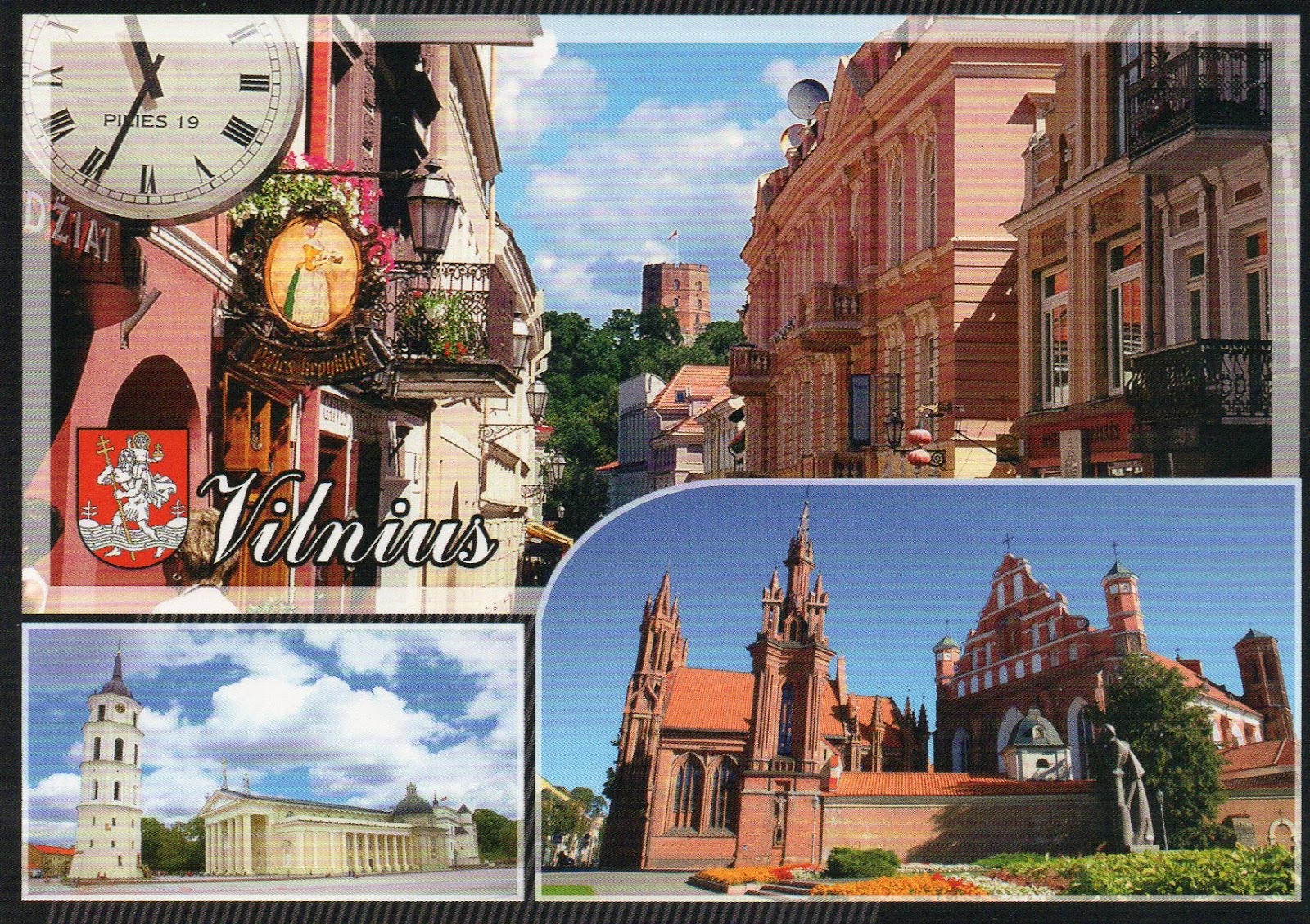
The Vilnius Historic Centre began its history on the glacial hills that had been intermittently occupied from the Neolithic period; a wooden castle was built around 1000 AD to fortify Gedimino Hill, at the confluence of the Neris and Vilnia rivers. The settlement did not develop as a town until the 13th century, during the struggles of the Baltic peoples against their German invaders. By 1323, when the first written reference to Vilnia occured, it was the capital of the Grand Duchy of Lithuania. (...) By the 15th century, the Grand Duchy of Lithuania, with its capital Vilnius, had become the largest country in Europe, stretching from the Baltic Sea in the North to the Black Sea in the South. The historic centre comprises the areas of the three castles (Upper, Lower and Curved) and the area that was encircled by a wall in the Middle Ages. The plan is basically circular, radiating out from the original castle site. The street pattern is typically medieval, with small streets dividing it into irregular blocks, but with large squares inserted in later periods.

Vilnius

The historic buildings are in Gothic, Renaissance, Baroque and Classical styles and have a distinct appearance, spatial composition, and elements of internal and external finishes. They constitute a townscape of great diversity and yet at the same time demonstrating an overarching harmony. - in: http://whc.unesco.org/en/list/541
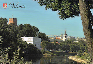
Gediminas' Tower
This postcard was sent by Ernesta

Gediminas' Tower (LithuanianGedimino pilies bokštas) is the remaining part of the Upper Castle in VilniusLithuania.
The first wooden fortifications were built by GediminasGrand Duke of Lithuania. The first brick castle was completed in 1409 by Grand Duke Vytautas. The three-floor tower was rebuilt in 1930 by Polish architect Jan Borowski. Some remnants of the old castle have been restored, guided by archaeological research.
Gediminas' Tower is an important state and historic symbol of the city of Vilnius and of Lithuania itself. It was depicted on the former national currency, the litas, and is mentioned in numerous Lithuanian patriotic poems and folk songs. - in: wikipedia
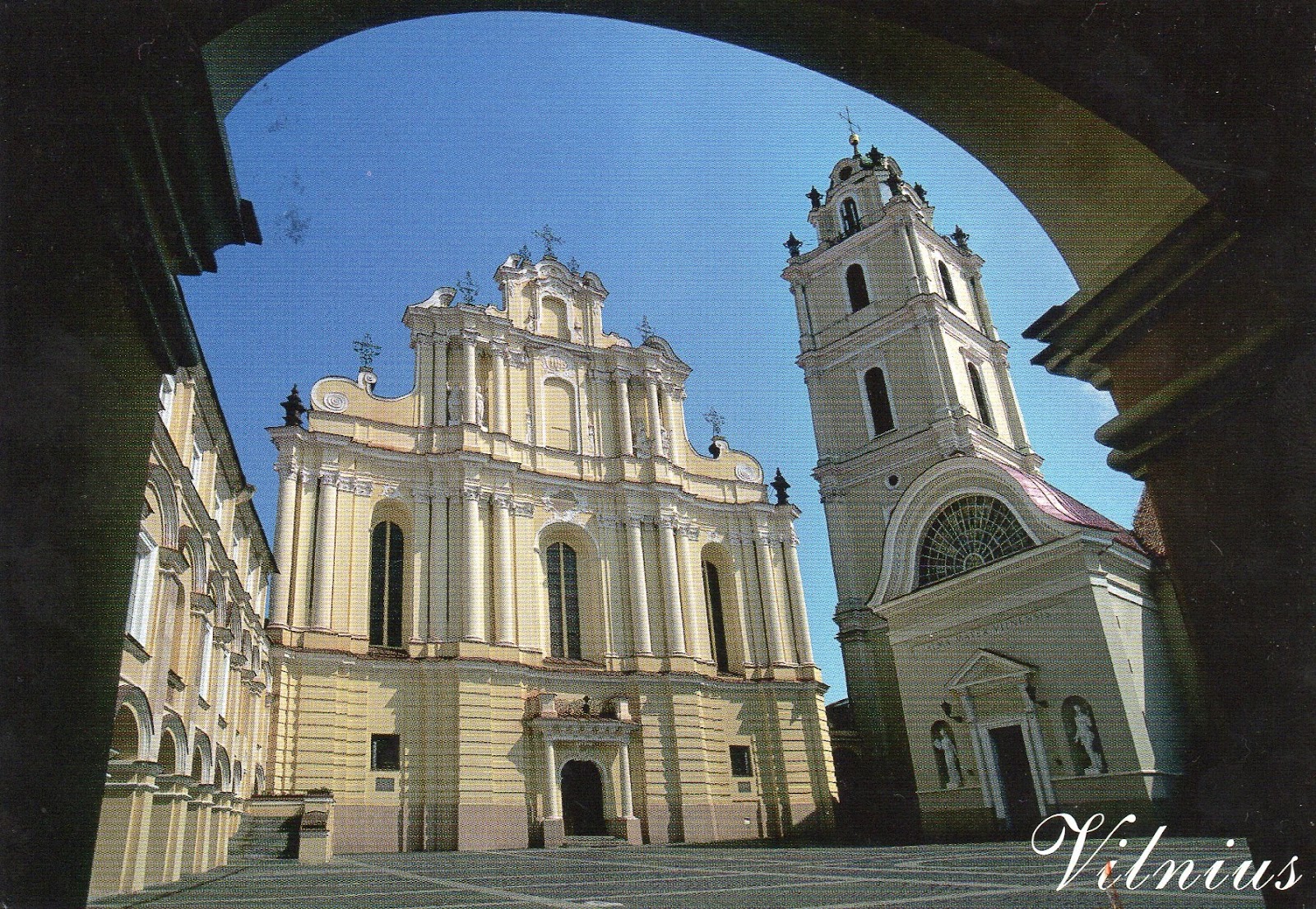
Church of St. Johns
This postcard was sent by Paulius

The Church of St. JohnsSt. John the Baptist and St. John the Apostle and Evangelist is located at the Old Town of VilniusLithuania and dominates the university (Vilnius University) ensemble. Since the times of the Jesuit Academy professors and students used to pray here, and Vilnius theologians gave sermons.
The church was built in 1388–1426, reconstructed in the 16th and 17th centuries. The tower, separate from the church itself, was built in the 16th century. After the fire in 1737, from 1738–1748, architect Johann Christoph Glaubitz completely reconstructed the church in style of late Baroque. During the 1827-28 reconstruction, architect Karol Podczaszynski destroyed the bulk of the sumptuous Baroque interior - nearly 3000 carts with splinters of altars, sculptures and stucco works were taken to a dump; chapels suffered the least. - in: wikipedia


Vilnius Cathedral
This postcard was sent by Valdemara


The Cathedral Basilica of St Stanislaus and St Ladislaus of Vilnius is the main Roman Catholic Cathedral of Lithuania. It is situated in Vilnius Old Town, just off of Cathedral Square. Dedicated to Saints Stanislaus and Ladislaus, the church is the heart of Catholic spiritual life in Lithuania.

Vilnius Cathedral

This postcard was sent by Audrius 

Inside, there are more than forty works of art dating from the 16th through 19th centuries, including frescoes and paintings of various sizes. During the restoration of the Cathedral, the altars of a presumed pagan temple and the original floor, laid during the reign of King Mindaugas, were uncovered. In addition, the remains of the cathedral built in 1387 were also located. A fresco dating from the end of the 14th century, the oldest known fresco in Lithuania, was found on the wall of one of the cathedral's underground chapels. - in: wikipedia

Tuesday 30 June 2020

Fortifications of Vauban

Of the 12 fortifications of Vauban inscribed in the UNESCO World Heritage list I have postcards of eight and I have already been in two: Besançon and Neuf-Brisach. I enjoyed more Besançon because it has a lot more to see than just the citadel

Citadel of Arras
This postcard was sent by Axel

Built by Vauban between 1667 and 1672, the Citadel has been nicknamed La belle inutile (the beautiful useless one) by residents as it has never been directly involved in heavy fighting and didn't prevent the Germans from occupying the city in either World War. Since 7 July 2008 it has been part of the UNESCO World Heritage Sites Fortifications of Vauban which includes eleven other fortifications. Within the citadel on the side of La Place de Manœuvre a small Baroque-style chapel was built. Outside, Le Mur des Fusillés (the wall of the people executed by a firing squad) pays tribute to the 218 members of the French Resistance shot in the citadel's ditch during World War II. - in: wikipedia

Citadel of Besançon
The Citadel of Besançon in Franche-Comté, France, is one of the finest masterpieces of military architecture designed by Sébastien Le Prestre de Vauban. The Citadel occupies eleven hectares on Mount Saint-Etienne, one of the seven hills that protect Besançon, the capital of Franche-Comté. Mount Saint-Etienne occupies the neck of an oxbow formed by the river Doubs, giving the site a strategic importance that Julius Caesar recognised as early as 58 BC. The Citadel overlooks the old quarter of the city, which is located within the oxbow, and offers a magnificent view of the entire city and its surroundings.
The fortification is well preserved. Today it is an important tourist site (over a quarter of a million visitors per year) due both to its own characteristics and because it is the site of several museums. - in: wikipedia

Citadel of Besançon
The Citadel is built on top of a large syncline on a rectangular field crossed across its width by three successive bastions (enclosures, or fronts) behind which extend three plazas. The whole is surrounded by walls covered by circular paths and punctuated by watchtowers and sentry posts. The walls are up to 15 to 20 metres (49 to 66 ft) high with a thickness between 5 and 6 metres (16 and 20 ft). - in: wikipedia


Porte Noire and Cathedral of St. Jean
The city has one of the most beautiful historic centers of any major town in France. A broad horse-shoe of the river Doubs, "la Boucle", encircles the old town, while Vauban's imposing Citadelle blocks off the neck. The historic center presents a remarkable ensemble of classic stone buildings, some dating back to the Middle Ages and others to the Spanish Renaissance.
The Roman remains consist primarily of the Porte Noire, a 2nd-century CE triumphal arch at the foot of the hill on which the citadel stands, and the Square Castan, a semi-circular amphitheater. The Porte Noire may commemorate the victories of Marcus Aurelius over the Germans in 167 CE. It was partly rebuilt in 1820.

Besançon Cathedral (Cathédrale Saint-Jean de Besançon) is a Roman Catholic cathedral located in the town of Besançon, France. It is the seat of the Archbishop of Besançon.
The cathedral is sited near the base of Mont Saint-Étienne, below the citadel. To the east of the cathedral is the 16th century Porte Rivotte, with two round towers, and pedestrian walkways dating to the 19th century. To the west is the Porte Noire, a Roman triumphal arch of the 2nd century with extensive sculptural decoration.
The cathedral consists of a large nave between two aisles, and dates from the 11th to the 13th century, with an 18th-century quire. - in: wikipedia

Citadel of Blaye
This postcard was sent by Joana


Designed by the 17th century architect, Sébastien Le Prestre, Marquis of Vaubanthe Citadel of Blaye, along with the Paté fort and the Médoc fort, forms part of “Vauban’s bolt”: a three part fortification designed to defend Bordeaux from its enemies arriving from the Atlantic. - in: https://www.bordeauxwinetrip.com/Discover-the-vineyards/Bordeaux-s-wine-routes/Blaye-and-Bourg/The-Citadel-of-Blaye

Fortified town, Pont d'Asfeld and Collegiate Churh of Notre-Dame
This postcard was sent by Steffi

Briançon a commune in the Hautes-Alpes department in the Provence-Alpes-Côte d'Azur region in southeastern France.
The historical centre is a strongly fortified town, built by Vauban to defend the region from Austrians in the 17th century. Its streets are very steep and narrow, though picturesque. 
The Pont d'Asfeld, east of the town, was built in 1734, and forms an arch of 40 m span, thrown at a height of 56 m across the Durance.
The parish church, with its two towers, was built 1703–1726, and occupies a very conspicuous position. - in: wikipedia

Tour Vauban
This postcard was sent by Javier

The Tour Vauban (Vauban Tower), initially known as the tour de Camaret, is an 18m-high polygonal defensive tower built to a plan by Vauban on the Sillon at Camaret-sur-Mer, as part of the fortifications of the goulet de Brest. It has three levels and is flanked by walls, a guardhouse and a gun battery which can hold 11 cannons as well as a cannonball foundry added in the French Revolution period.
Drafted in 1683, the tower was designed in 1689 by Vauban and construction was supervised by the military engineer Jean-Pierre Traverse from 1693 to completion in 1696. - in: wikipedia

Neuf-Brisach
Neuf-Brisach is a fortified town and commune of the department of Haut-Rhin in the French region of Alsace. The fortified town was intended to guard the border between France and the Holy Roman Empire and, subsequently the German states. It was built after the peace of Ryswick, in 1697, that resulted in the loss to France of the town of Breisach, on the opposite bank of the Rhine. The town's name means New Breisach.

Neuf-Brisach
Work began on the fortified town in 1698, to plans drawn by Vauban, a military engineer at the service of Louis XIV. Vauban died in 1707 and this, his last work, was completed by Louis de Cormontaigne. The city's layout was that of an 'ideal city', as was popular at the time, with a regular square grid street pattern inside an octagonal fortification. Generous space was given to a central square across the four blocks at the middle, flanked by an impressive church. Individual blocks were offered for private development, either as affluent houses in private gardens, or as properties for commercial rent. Simpler housing was provided in long tenement blocks, built inside each curtain wall, which also had the effect of shielding the better houses from the risk of cannon fire. Access was provided by large gateways in the principal four curtain walls. - in: wikipedia


Saint-Martin-de-Ré
This postcard was sent by Axel


Saint-Martin-de-Ré has extensive fortifications, reflecting the strategic importance of the Île de Ré. During the Huguenot Rebellions of the 1620s, Cardinal Richelieu ordered that the island be fortified as a counterweight to the Protestant nearby city of La Rochelle on the French mainland. This included a citadel at Saint Martin. After La Rochelle had been subdued, Saint-Martin's fortification were largely demolished to remove its potential threat to royal power.
Later, in the 1670s, the French engineer, Vauban was commissioned to review and overhaul the island's defences and, as a result, Saint Martin was enclosed by extensive and modern walls and embankments. This was done in three major phases ending in 1702 and the end result was an enclosed town capable of housing the island's population for a long siege. - in: wikipedia


Villefranche-de-Conflent City Walls
This postcard was sent by Javier

First built in the Middle Ages, Villefranche-de-Conflent city walls were deeply transformed by Vauban during the 17th century. These walls are unique, because they are composed of two layered covered patrol path. 
After the Treaty of the Pyrenees (1659), the medieval ramparts were covered by a vault and Vauban decided to add another level with a traditional roof made of slate. 
Few medieval towers still exist, some of them being incorporated in the Vauban’s walls. Vauban adjusted the walls to the narrowness of the town and the proximity of the mountains. - in: http://villefranchedeconflent-tourisme.blogspot.com/p/the-walls.html

The 12 fortifications (in red what I already have):

  • La citadelle d’Arras
  • La citadelle, l’enceinte urbaine et le fort Griffon de Besançon
  • La citadelle et le fort Paté et Médoc de Blaye/Cussac-Fort-Médoc
  • L’enceinte urbaine, les forts des Salettes, des Trois-Tête, du Randoouillet et Dauphin, la communication Y et le pont d’Asfeld de Briançon
  • La tour Dorée de Camaret-sur-Mer
  • La place forte de Longwy
  • La place forte de Mont-Dauphin
  • L’enceinte et la citadelle de Mont-Louis
  • La place forte de Neuf-Brisach
  • La citadelle el l’enceinte de Saint-Martin-de-Ré
  • Les tours-observatoires de Tatihou et de la Hougue 
  • L’enceinte, le fort et la Cova Bastera de Villefranche-de-Conflent