Monday 30 March 2020

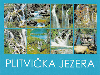
Plitvice Lakes National Park

This national park is world-famous for its blue lakes and cascades

Black River
This postcard was sent by Agi

Plitvice Lakes National Park (CroatianNacionalni park Plitvička jezera) is one of the oldest national parks in Southeast Europe and the largest national park in Croatia.
The national park was founded in 1949 and is situated in the mountainous karst area of central Croatia, at the border to Bosnia and Herzegovina. The important north-south road connection, which passes through the national park area, connects the Croatian inland with the Adriatic coastal region.

Plitvice Lakes
This postcard was sent by Steffi


The Plitvice Lakes originate in the south of the park area at the confluence of Bijela Rijeka (English White River) and Crna Rijeka (English Black River). - in: wikipedia


Sunday 29 March 2020

Old City of Dubrovnik

I said in other posts that I would love to visit Croatia and make stops in Split and in Trogir, but if I had to choose only one place of this country it would be Dubrovnik. The description in the UNESCO website as "Pearl of the Adriatic" must mean something :)

Dubrovnik
This postcard was sent by Antonella

Dubrovnik is a Croatian city on the Adriatic Sea, in the region of Dalmatia.(...) In 1979, the city of Dubrovnik joined the UNESCO list of World Heritage Sites.
The prosperity of the city was historically based on maritime trade; as the capital of the maritime Republic of Ragusa, it achieved a high level of development, particularly during the 15th and 16th centuries, as it became notable for its wealth and skilled diplomacy.


Dubrovnik
This postcard was sent by Steffi

According to CNNGo, Dubrovnik is among the 10 best preserved medieval walled cities in the world. Although it was demilitarised in the 1970s to protect it from war, in 1991, after the breakup of Yugoslavia, it was besieged by the Serb andMontenegrin soldiers gathered in the Yugoslav People's Army (JNA) for seven months and suffered significant damage from shelling. - in: wikipedia


Thursday 19 March 2020

Rjukan-Notodden Industrial Heritage Site

The Rjukan-Notodden site is located in a dramatic landscape of mountains, waterfalls and river valleys

Krossobanen - Rjukan
This postcard was sent by Doris

Krossobanen was built in 1928 and was a gift from Norsk Hydro, so the townspeople could get up to see the sun during the winter.
The Krossobane Cable Car was the first cable car to be built in northern Europe. It was built in 1928 and it was a gift from Norsk Hydro to the townspeople so that they could get up high enough to see the sun during the winter.
The lower station has a large car park, from which the two cable cars, "Tyttebær" (cranberry) and "Blåbær" (blueberry) carry passengers up to an altitude of 886 metres.
The view over Rjukan from the upper station is fantastic, with the mountains rolling away to the south and west and Vemork nestling in the valley where the dramatic heavy water sabotage operations took place during the WWII. - inhttps://www.visitnorway.com/listings/krossobanen/6389/

Sunday 15 March 2020

Tehuacán-Cuicatlán Valley: originary habitat of Mesoamerica

This is already my second postcard of a painting of José María Velasco

Cardón in Santa María Tecomavaca
This postcard was sent by Marco

Tehuacán-Cuicatlán Valley, part of the Mesoamerican region, is the arid or semi-arid zone with the richest biodiversity in all of North America. Consisting of three components, Zapotitlán-Cuicatlán, San Juan Raya and Purrón, it is one of the main centres of diversification for the cacti family, which is critically endangered worldwide. The valley harbours the densest forests of columnar cacti in the world, shaping a unique landscape that also includes agaves, yuccas and oaks. Archaeological remains demonstrate technological developments and the early domestication of crops. The valley presents an exceptional water management system of canals, wells, aqueducts and dams, the oldest in the continent, which has allowed for the emergence of agricultural settlements. - in: https://whc.unesco.org/en/list/1534/

Tehuacán-Cuicatlán Valley
This postcard was sent by Marco

Saturday 14 March 2020

Historic Centre of Prague

Prague is on the top of my list of cities that I want to visit and the more I read about it the more I want to go there

Old Town and New Town of Prague
This postcard was sent by Sam

Built between the 11th and 18th centuries, the Old Town, the Lesser Town and the New Town speak of the great architectural and cultural influence enjoyed by this city since the Middle Ages. The many magnificent monuments, such as Hradcani Castle, St Vitus Cathedral, Charles Bridge and numerous churches and palaces, built mostly in the 14th century under the Holy Roman Emperor, Charles IV. - in: http://whc.unesco.org/en/list/616

Old Town Square
Old Town Square is a historic square in the Old Town quarter of Prague, the capital of the Czech Republic.
The square features various architectural styles including the Gothic Church of Our Lady before Týn, which has been the main church of this part of the city since the 14th century; the church's towers are 80 m high. Prague Orloj is a medieval astronomical clock located on the Old Town Hall. The clock was first installed in 1410, making it the third-oldest astronomical clock in the world and the oldest one still in operation. - in: wikipedia


Old Town and Charles Bridge
This postcard was sent from Portugal by José "Pombal"

The Old Town of Prague is a medieval settlement of PragueCzech Republic. It was separated from the outside by a semi-circular moat and wall, connected to the Vltava river at both of its ends.
The Old Town is surrounded by the New Town of Prague. Across the river Vltava connected by the Charles Bridge is the Lesser Town of Prague. - in: wikipedia

Charles Bridge
The Charles Bridge (CzechKarlův most) is an historic bridge that crosses the Vltava river in Prague, Czech Republic. Its construction started in 1357 under the auspices of King Charles IV, and finished in the beginning of the 15th century. The bridge replaced the old Judith Bridge built 1158–1172 that had been badly damaged by a flood in 1342. This new bridge was originally called the Stone Bridge (Kamenný most) or the Prague Bridge (Pražský most) but has been the "Charles Bridge" since 1870. As the only means of crossing the river Vltava (Moldau) until 1841, the Charles Bridge was the most important connection between Prague Castle and the city's Old Town and adjacent areas.


Charles Bridge
 This postcard was sent by Martin

The bridge is decorated by a continuous alley of 30 statues and statuaries, most of them baroque-style, originally erected around 1700 but now all replaced by replicas. - in: wikipedia


Lesser Town of Prague
This postcard was sent from Belarus by Marina 

Malá Strana (Czech for "Little Side (of the River)",  or more officially Menší Město pražské (English: Lesser Town of Prague) is a district of the city of PragueCzech Republic, and one of its most historic regions.
Baroque architecture predominates in Malá Strana, but the history of the district dates back to far before the Baroque era. Baroque architecture eventually dominated when the style became successfully implanted on Malá Strana after the district was devastated by fires in 1541. - in: wikipedia


Prague
This postcard was sent from China by Ruinan Wang


Monday 9 March 2020

Koutammakou, the Land of the Batammariba

These traditional mud houses are known as a national symbol of Togo

Koutammakou
This postcard was sent by Mike

The Koutammakou landscape in north-eastern Togo, which extends into neighbouring Benin, is home to the Batammariba whose remarkable mud tower-houses (Takienta) have come to be seen as a symbol of Togo. In this landscape, nature is strongly associated with the rituals and beliefs of society. The 50,000-ha cultural landscape is remarkable due to the architecture of its tower-houses which are a reflection of social structure; its farmland and forest; and the associations between people and landscape. Many of the buildings are two storeys high and those with granaries feature an almost spherical form above a cylindrical base. Some of the buildings have flat roofs, others have conical thatched roofs. They are grouped in villages, which also include ceremonial spaces, springs, rocks and sites reserved for initiation ceremonies. - in: https://whc.unesco.org/en/list/1140

Tuesday 3 March 2020

Dilmun Burial Mounds

This postcard, from a very recent UNESCO site, is only my second from Bahrain

Dilmun Burial Mounds

The Dilmun Burial Mounds, built between 2200 and 1750 BCE, span over 21 archaeological sites in the western part of the island. Six of these sites are burial mound fields consisting of a few dozen to several thousand tumuli. In all there are about 11,774 burial mounds, originally in the form of cylindrical low towers. The other 15 sites include 17 royal mounds, constructed as two-storey sepulchral towers. The burial mounds are evidence of the Early Dilmun civilization, around the 2nd millennium BCE, during which Bahrain became a trade hub whose prosperity enabled the inhabitants to develop an elaborate burial tradition applicable to the entire population. These tombs illustrate globally unique characteristics, not only in terms of their number, density and scale, but also in terms of details such as burial chambers equipped with alcoves. - in: https://whc.unesco.org/en/list/1542/