Of the 12 fortifications of Vauban inscribed in the UNESCO World Heritage list I have postcards of eight and I have already been in two: Besançon and Neuf-Brisach. I enjoyed more Besançon because it has a lot more to see than just the citadel
 |
| Citadel of Arras |
This postcard was sent by Axel
Built by Vauban between 1667 and 1672, the Citadel has been nicknamed La belle inutile (the beautiful useless one) by residents as it has never been directly involved in heavy fighting and didn't prevent the Germans from occupying the city in either World War. Since 7 July 2008 it has been part of the UNESCO World Heritage Sites Fortifications of Vauban which includes eleven other fortifications. Within the citadel on the side of La Place de Manœuvre a small Baroque-style chapel was built. Outside, Le Mur des Fusillés (the wall of the people executed by a firing squad) pays tribute to the 218 members of the French Resistance shot in the citadel's ditch during World War II. - in: wikipedia
 |
| Citadel of Besançon |
The Citadel of Besançon in Franche-Comté, France, is one of the finest masterpieces of military architecture designed by Sébastien Le Prestre de Vauban. The Citadel occupies eleven hectares on Mount Saint-Etienne, one of the seven hills that protect Besançon, the capital of Franche-Comté. Mount Saint-Etienne occupies the neck of an oxbow formed by the river Doubs, giving the site a strategic importance that Julius Caesar recognised as early as 58 BC. The Citadel overlooks the old quarter of the city, which is located within the oxbow, and offers a magnificent view of the entire city and its surroundings.
The fortification is well preserved. Today it is an important tourist site (over a quarter of a million visitors per year) due both to its own characteristics and because it is the site of several museums. - in: wikipedia
 |
| Citadel of Besançon |
The Citadel is built on top of a large syncline on a rectangular field crossed across its width by three successive bastions (enclosures, or fronts) behind which extend three plazas. The whole is surrounded by walls covered by circular paths and punctuated by watchtowers and sentry posts. The walls are up to 15 to 20 metres (49 to 66 ft) high with a thickness between 5 and 6 metres (16 and 20 ft). - in: wikipedia
 |
| Porte Noire and Cathedral of St. Jean |
The city has one of the most beautiful historic centers of any major town in France. A broad horse-shoe of the river Doubs, "la Boucle", encircles the old town, while Vauban's imposing Citadelle blocks off the neck. The historic center presents a remarkable ensemble of classic stone buildings, some dating back to the Middle Ages and others to the Spanish Renaissance.
The Roman remains consist primarily of the Porte Noire, a 2nd-century CE triumphal arch at the foot of the hill on which the citadel stands, and the Square Castan, a semi-circular amphitheater. The Porte Noire may commemorate the victories of Marcus Aurelius over the Germans in 167 CE. It was partly rebuilt in 1820.
Besançon Cathedral (Cathédrale Saint-Jean de Besançon) is a Roman Catholic cathedral located in the town of Besançon, France. It is the seat of the Archbishop of Besançon.
The cathedral is sited near the base of Mont Saint-Étienne, below the citadel. To the east of the cathedral is the 16th century Porte Rivotte, with two round towers, and pedestrian walkways dating to the 19th century. To the west is the Porte Noire, a Roman triumphal arch of the 2nd century with extensive sculptural decoration.
The cathedral consists of a large nave between two aisles, and dates from the 11th to the 13th century, with an 18th-century quire. - in: wikipedia
 |
| Citadel of Blaye |

Designed by the 17th century architect, Sébastien Le Prestre, Marquis of Vauban, the Citadel of Blaye, along with the Paté fort and the Médoc fort, forms part of “Vauban’s bolt”: a three part fortification designed to defend Bordeaux from its enemies arriving from the Atlantic. - in: https://www.bordeauxwinetrip.com/Discover-the-vineyards/Bordeaux-s-wine-routes/Blaye-and-Bourg/The-Citadel-of-Blaye
 |
| Fortified town, Pont d'Asfeld and Collegiate Churh of Notre-Dame |
This postcard was sent by Steffi
Briançon a commune in the Hautes-Alpes department in the Provence-Alpes-Côte d'Azur region in southeastern France.
The historical centre is a strongly fortified town, built by Vauban to defend the region from Austrians in the 17th century. Its streets are very steep and narrow, though picturesque.
The Pont d'Asfeld, east of the town, was built in 1734, and forms an arch of 40 m span, thrown at a height of 56 m across the Durance.
The parish church, with its two towers, was built 1703–1726, and occupies a very conspicuous position. - in: wikipedia
This postcard was sent by Javier
The Tour Vauban (Vauban Tower), initially known as the tour de Camaret, is an 18m-high polygonal defensive tower built to a plan by Vauban on the Sillon at Camaret-sur-Mer, as part of the fortifications of the goulet de Brest. It has three levels and is flanked by walls, a guardhouse and a gun battery which can hold 11 cannons as well as a cannonball foundry added in the French Revolution period.
Drafted in 1683, the tower was designed in 1689 by Vauban and construction was supervised by the military engineer Jean-Pierre Traverse from 1693 to completion in 1696. - in: wikipedia
 |
| Tour Vauban |
The Tour Vauban (Vauban Tower), initially known as the tour de Camaret, is an 18m-high polygonal defensive tower built to a plan by Vauban on the Sillon at Camaret-sur-Mer, as part of the fortifications of the goulet de Brest. It has three levels and is flanked by walls, a guardhouse and a gun battery which can hold 11 cannons as well as a cannonball foundry added in the French Revolution period.
Drafted in 1683, the tower was designed in 1689 by Vauban and construction was supervised by the military engineer Jean-Pierre Traverse from 1693 to completion in 1696. - in: wikipedia
 |
| Neuf-Brisach |
Neuf-Brisach is a fortified town and commune of the department of Haut-Rhin in the French region of Alsace. The fortified town was intended to guard the border between France and the Holy Roman Empire and, subsequently the German states. It was built after the peace of Ryswick, in 1697, that resulted in the loss to France of the town of Breisach, on the opposite bank of the Rhine. The town's name means New Breisach.
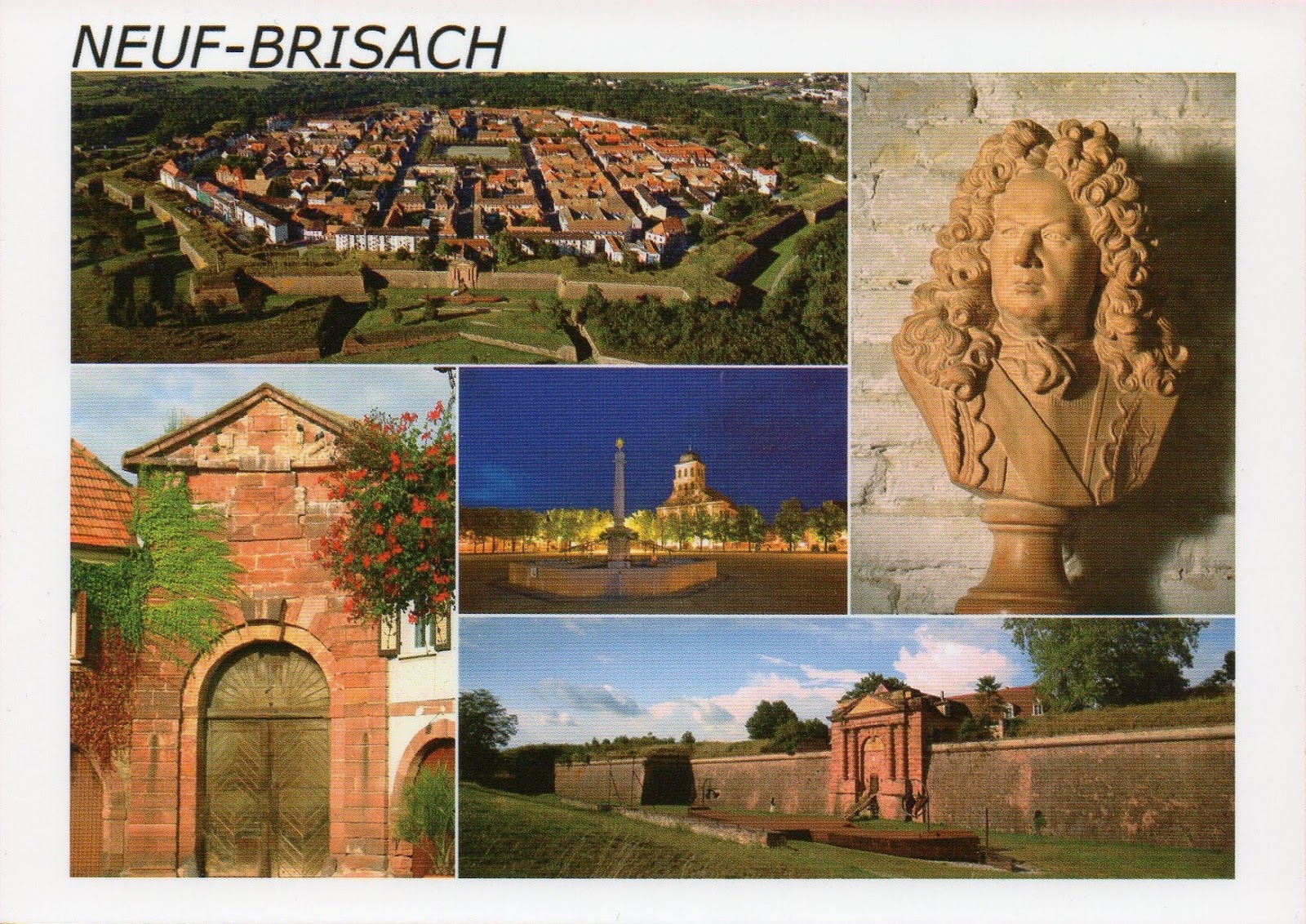 |
| Neuf-Brisach |
Work began on the fortified town in 1698, to plans drawn by Vauban, a military engineer at the service of Louis XIV. Vauban died in 1707 and this, his last work, was completed by Louis de Cormontaigne. The city's layout was that of an 'ideal city', as was popular at the time, with a regular square grid street pattern inside an octagonal fortification. Generous space was given to a central square across the four blocks at the middle, flanked by an impressive church. Individual blocks were offered for private development, either as affluent houses in private gardens, or as properties for commercial rent. Simpler housing was provided in long tenement blocks, built inside each curtain wall, which also had the effect of shielding the better houses from the risk of cannon fire. Access was provided by large gateways in the principal four curtain walls. - in: wikipedia
 This postcard was sent by Axel
 |
| Saint-Martin-de-Ré |

Saint-Martin-de-Ré has extensive fortifications, reflecting the strategic importance of the Île de Ré. During the Huguenot Rebellions of the 1620s, Cardinal Richelieu ordered that the island be fortified as a counterweight to the Protestant nearby city of La Rochelle on the French mainland. This included a citadel at Saint Martin. After La Rochelle had been subdued, Saint-Martin's fortification were largely demolished to remove its potential threat to royal power.
Later, in the 1670s, the French engineer, Vauban was commissioned to review and overhaul the island's defences and, as a result, Saint Martin was enclosed by extensive and modern walls and embankments. This was done in three major phases ending in 1702 and the end result was an enclosed town capable of housing the island's population for a long siege. - in: wikipedia
This postcard was sent by Javier
First built in the Middle Ages, Villefranche-de-Conflent city walls were deeply transformed by Vauban during the 17th century. These walls are unique, because they are composed of two layered covered patrol path.
After the Treaty of the Pyrenees (1659), the medieval ramparts were covered by a vault and Vauban decided to add another level with a traditional roof made of slate.
Few medieval towers still exist, some of them being incorporated in the Vauban’s walls. Vauban adjusted the walls to the narrowness of the town and the proximity of the mountains. - in: http://villefranchedeconflent-tourisme.blogspot.com/p/the-walls.html
 |
| Villefranche-de-Conflent City Walls |
First built in the Middle Ages, Villefranche-de-Conflent city walls were deeply transformed by Vauban during the 17th century. These walls are unique, because they are composed of two layered covered patrol path.
After the Treaty of the Pyrenees (1659), the medieval ramparts were covered by a vault and Vauban decided to add another level with a traditional roof made of slate.
Few medieval towers still exist, some of them being incorporated in the Vauban’s walls. Vauban adjusted the walls to the narrowness of the town and the proximity of the mountains. - in: http://villefranchedeconflent-tourisme.blogspot.com/p/the-walls.html
The 12 fortifications (in red what I already have):
- La citadelle d’Arras
- La citadelle, l’enceinte urbaine et le fort Griffon de Besançon
- La citadelle et le fort Paté et Médoc de Blaye/Cussac-Fort-Médoc
- L’enceinte urbaine, les forts des Salettes, des Trois-Tête, du Randoouillet et Dauphin, la communication Y et le pont d’Asfeld de Briançon
- La tour Dorée de Camaret-sur-Mer
- La place forte de Longwy
- La place forte de Mont-Dauphin
- L’enceinte et la citadelle de Mont-Louis
- La place forte de Neuf-Brisach
- La citadelle el l’enceinte de Saint-Martin-de-Ré
- Les tours-observatoires de Tatihou et de la Hougue
- L’enceinte, le fort et la Cova Bastera de Villefranche-de-Conflent


