Saturday, 26 December 2015

Imperial Palaces of the Ming and Qing Dynasties in Beijing and Shenyang

This site always brings me to my memory the film The Last Emperor, and now that I'm posting this I want to see it again because it was a long time ago that I watched it on TV and I can hardly remember. 

The Forbidden City
This postcard was sent by Ashley

The Forbidden City was the Chinese imperial palace from the Ming dynasty to the end of the Qing dynasty—the years 1420 to 1912. It is located in the center of Beijing, China, and now houses the Palace Museum. It served as the home of emperor sand their households as well as the ceremonial and political centre of Chinese government for almost 500 years.
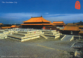
The Forbidden City

This postcard was sent by Luo

Constructed from 1406 to 1420, the complex consists of 980 buildings and covers 72 ha (180 acres). The palace complex exemplifies traditional Chinese palatial architecture, and has influenced cultural and architectural developments in East Asia and elsewhere. The Forbidden City was declared a World Heritage Site in 1987, and is listed by UNESCO as the largest collection of preserved ancient wooden structures in the world.

The Empress Bedroom
This postcard was sent by Lainey

Since 1925, the Forbidden City has been under the charge of the Palace Museum, whose extensive collection of artwork and artefacts were built upon the imperial collections of the Ming and Qing dynasties. Part of the museum's former collection is now located in the National Palace Museum in Taipei. Both museums descend from the same institution, but were split after the Chinese Civil War. The Forbidden City has over 14 million annual visitors. - in: wikipedia


Saturday, 19 December 2015

Imperial Tombs of the Ming and Qing Dynasties

This site includes several tombs and burial complexes. 14 tombs or tomb groups to be precise. I have 2. Not bad! :)

Ming Tombs - Sacred Way

This postcard was sent by Xiao

The Ming tombs are a collection of mausoleums built by the emperors of the Ming dynasty of China. The first Ming emperor's tomb is located near his capital Nanjing. However, the majority of the Ming tombs are located in a cluster near Beijing and collectively known as the Thirteen Tombs of the Ming Dynasty. They are within the suburban Changping District of Beijing municipality 42 kilometres (26 mi) north-northwest of Beijing city center. The site, on the southern slope of Tianshou Mountain (originally Huangtu Mountain), was chosen based on the principles of feng shuiby the third Ming emperor, the Yongle Emperor. After the construction of the Imperial Palace (Forbidden City) in 1420, the Yongle Emperor selected his burial site and created his own mausoleum. The subsequent emperors placed their tombs in the same valley. - in: wikipedia

Ming Xiaoling Mausoleum - Stone Pillar on Sacred Way
This postcard was sent by San-Aiolia

The Ming Xiaoling Mausoleum (Chinese明孝陵pinyinMíng Xiào Líng; literally: "Ming filial mausoleum") is the tomb of the Hongwu Emperor, the founder of the Ming dynasty. It lies at the southern foot of Purple Mountain, located east of the historical centre of NanjingChina. Legend says that in order to prevent robbery of the tomb, 13 identical processions of funeral troops started from 13 city gates to obscure the real burying site.
The construction of the mausoleum began during the Hongwu Emperor's life in 1381 and ended in 1405, during the reign of his son the Yongle Emperor, with a huge expenditure of resources involving 100,000 labourers. The original wall of the mausoleum was more than 22.5 kilometres long. The mausoleum was built under heavy guard of 5,000 troops. - in: wikipedia

Thursday, 17 December 2015

Historical Complex of Split with the Palace of Diocletian

 As I said before Croatia is a country that I'd love to visit and I would definitely love to make a long stop in Split.  
Split
This postcard was sent by Zana

Split is the second-largest city of Croatia and the largest city of the region of Dalmatia. It lies on the eastern shore of the Adriatic Sea, centred on the Roman Palace of the Emperor Diocletian. Spread over a central peninsula and its surroundings, Split's greater area includes the neighboring seaside towns as well. An intraregional transport hub and popular tourist destination, the city is a link to numerous Adriatic islands and the Apennine peninsula. - in: wikipedia

Split
This postcard was sent by Steffi

Diocletian's Palace (CroatianDioklecijanova palača) is an ancient palace built by the Roman emperor Diocletian at the turn of the fourth century AD, that today forms the center of the city of Split. While it is referred to as a "palace" because of its intended use as the retirement residence of Diocletian, the term can be misleading as the structure is massive and more resembles a large fortress: about half of it was for Diocletian's personal use, and the rest housed the military garrison.
Today the palace, along with adjoining areas to the west, forms the very heart of Split. Many shops, restaurants, bars and apartments for tourists can be found within the palace. - in: wikipedia

Wednesday, 16 December 2015

Historic City of Trogir

Croatia is one of the many European countries that I'd love to visit and Trogir a must stop point.

Trogir
This postcard was sent by Agi

Trogir is a remarkable example of urban continuity. The orthogonal street plan of this island settlement dates back to the Hellenistic period and it was embellished by successive rulers with many fine public and domestic buildings and fortifications. Its beautiful Romanesque churches are complemented by the outstanding Renaissance and Baroque buildings from the Venetian period. - in: http://whc.unesco.org/en/list/810/

Willandra Lakes Region

Postcards are a wonderful way to learn about the world. When I knew that I was going to receive a postcard from a place called Willandra Lakes Region, I wasn't expecting a postcard that only shows desert and sand... But then I researched and now I know why this place is called this way. Always learning! :) 

Mungo National Park
This postcard was sent by Norma

The Mungo National Park is a protected national park that is located in south-western New South Wales, in eastern Australia
The national park is part of the UNESCO World Heritage–listed Willandra Lakes Region, an area of 2,400 square kilometres (930 sq mi) that incorporates seventeen dry lakes. The seventeen dry lakes are not all called mungo but are all declared world heritage, also the creek that used to flow into mungo is being preserved as a sacred site.
The central feature of Mungo National Park is Lake Mungo, the second largest of the ancient dry lakes. The Mungo National Park is noted for the archaeological remains discovered in the park. The remains of Mungo Man, the oldest human remains discovered in Australia, and Mungo Lady, the oldest known human to have been ritually cremated, were both discovered within the park. They were buried on the shore of Lake Mungo, beneath the 'Walls of China', a series of lunettes on the South eastern edge of the lake. - in: wikipedia

Tuesday, 15 December 2015

Kakadu National Park

This was the first UNESCO site that I received from the amazing country that must be Australia!

Wetland in Kakadu National Park
 This postcard was sent by Norma

This unique archaeological and ethnological reserve, located in the Northern Territory, has been inhabited continuously for more than 40,000 years. The cave paintings, rock carvings and archaeological sites record the skills and way of life of the region’s inhabitants, from the hunter-gatherers of prehistoric times to the Aboriginal people still living there. It is a unique example of a complex of ecosystems, including tidal flats, floodplains, lowlands and plateaux, and provides a habitat for a wide range of rare or endemic species of plants and animals. - in: http://whc.unesco.org/en/list/147

Nourlangie Rock and Anbangbang Billabong; Kakadu waterfall; Black-necked Stork
This postcard was sent by Rosie

Burrunggui (previously called Nourlangie Rock) is located in an outlying formation of the Arnhem Land Escarpment within the Kakadu National Park which is in the Northern Territory of Australia. It can be reached off the Kakadu Highway between Jabiru and Cooinda. The word Nourlangie derives from the Gundjeihmi language placename Nawurlandja which is actually the name of a smaller rock outcrop at the Anbangbang billabong.

Anbangbang Billabong lies in the shadow of Nourlangie Rock within Kakadu National Park and is a good place to view a wide range of wildlife. Large numbers of water fowl and wading birds inhabit the billabong and many wallabies can be found grazing around the water’s edge.

The black-necked stork (Ephippiorhynchus asiaticus) is a tall long-necked wading bird in the stork family. It is a resident species across South and Southeast Asia with a disjunct population in Australia. It lives in wetland habitats where it forages for a wide range of animal prey. Adult birds of both sexes have a heavy bill and are patterned in white and glossy blacks, but the sexes differ in the colour of the iris. In Australia, it is sometimes called a jabiru although that name refers to a stork species found in the Americas. It is one of the few storks that is strongly territorial when feeding. - in: wikipedia

Great Barrier Reef

The world's largest collection of coral reefs. Amazing!

Great Barrier Reef
The Great Barrier Reef is a site of remarkable variety and beauty on the north-east coast of Australia. It contains the world’s largest collection of coral reefs, with 400 types of coral, 1,500 species of fish and 4,000 types of mollusc. It also holds great scientific interest as the habitat of species such as the dugong (‘sea cow’) and the large green turtle, which are threatened with extinction. - in: http://whc.unesco.org/en/list/154

Madriu-Perafita-Claror Valley

In 2013 Marta, Miguel and Vitória, 3 Portuguese Postcrossers, went on a trip through Barcelona and Andorra. It was from Andorra that they sent me this postcard.

Madriu River

The Madriu-Perafita-Claror Valley (CatalanVall del Madriu-Perafita-Claror) is a glacial valley in the southeast of Andorra. It covers an area of 42.47 km², approximately 9% of the total area of Andorra, and is part of the second largest watershed basin in Andorra. The isolated valley is recognised as a haven for rare or endangered wildlife, and the undeveloped valley has recently been considered to be the "spiritual heart" of Andorra. It became Andorra's first, and to date its only, UNESCO World Heritage Site in 2004, with a small extension in 2006. - in: wikipedia

Tassili n'Ajjer

This was my first postcard, and so far the only one, from Algeria. It was sent from the United States by Dylan.

Tassili n'Ajjer and the Tuareg
Located in a strange lunar landscape of great geological interest, this site has one of the most important groupings of prehistoric cave art in the world. More than 15,000 drawings and engravings record the climatic changes, the animal migrations and the evolution of human life on the edge of the Sahara from 6000 BC to the first centuries of the present era. The geological formations are of outstanding scenic interest, with eroded sandstones forming ‘forests of rock’. - in: http://whc.unesco.org/en/list/179

Monday, 14 December 2015

Península Valdés

Sini, from Finland, also sent me this amazing postcard of the Península Valdés in Argentina, country that she visited in 2011.

Península Valdés in Patagonia is a site of global significance for the conservation of marine mammals. It is home to an important breeding population of the endangered southern right whale as well as important breeding populations of southern elephant seals and southern sea lions. The orcas in this area have developed a unique hunting strategy to adapt to local coastal conditions. . in: http://whc.unesco.org/en/list/937/

Young Southern Right Whale

The southern right whale (Eubalaena australis) is a baleen whale, one of three species classified as right whales belonging to the genus Eubalaena. Like other right whales, the southern right whale is readily distinguished from others by the callosities on its head, a broad back without a dorsal fin, and a long arching mouth that begins above the eye. Its skin is very dark grey or black, occasionally with some white patches on the belly. (...) Approximately 10,000 southern right whales are spread throughout the southern part of the Southern Hemisphere.
The size of an adult female is 15 m (49 ft) and can weigh up to 47 tonnes (46 long tons; 52 short tons), with the larger records of 17.5–18 m (57–59 ft) in length and 80 tonnes (79 long tons; 88 short tons) in weight,[13] making them slightly smaller than other right whales in Northern Hemisphere. - in: wikipedia

Saturday, 12 December 2015

Butrint

On a trip to Greece, Sini from Finland took a day to go to Albania and visited Butrint

Amphitheatre of Butrint

Buthrotum (AlbanianButrint) was an ancient Greek and later Roman city in Epirus. In modern times it is an archeological site in Vlorë CountyAlbania, some 14 kilometres south of Sarandë and close to the Greek border. It was known in antiquity as Βουθρωτόν (Bouthrōton) or (Βουθρώτιος) Bouthrōtios in Ancient Greek and Buthrotum in Latin. It is located on a hill overlooking the Vivari Channel and part of the Butrint National Park. Inhabited since prehistoric times, Buthrotum was a city of the Greek tribe of the Chaonians, later a Roman colony and abishopric. It entered into decline in Late Antiquity, before being abandoned during the Middle Ages after a major earthquake flooded most of the city. - in: wikipedia

Walled City of Baku with the Shirvanshah's Palace and Maiden Tower

This is so far my only postcard of Azerbaijan. Arrived from Canada and it was sent by Jason who lived in Baku in the end of the 90's.

Maiden Tower

The Maiden Tower (AzerbaijaniQız Qalası), also known locally as Giz Galasi, located in the Old CityBaku, in Azerbaijan, was built in the 12th century as part of the walled city. Together with the Shirvanshahs' Palace, dated to the 15th century, it forms an ensemble of historic monuments inscribed in 2001 under the UNESCO World Heritage List of Historical Monuments as cultural property, Category III. It is one of Azerbaijan's most distinctive national emblems, and is thus featured on Azeri currency notesand official letterheads. - in: wikipedia

Historic Centre of Santa Ana de los Ríos de Cuenca

Cuenca is located in the highlands of Ecuador at about 2,500 meters above sea level.

New Cathedral of Cuenca
This postcard was sent by Steffi

The Cathedral of the Immaculate Conception (SpanishCatedral de la Inmaculada Concepción), commonly referred to the as the New Cathedral of Cuenca (SpanishNueva Catedral de Cuenca), is the cathedral church in CuencaEcuador. It is situated in front of Parque Calderon.
The plan of the Cathedral was drawn up by Juan Bautista Stiehle (1829-1899) — a German-born friar who arrived in Cuenca from Alsace in 1873 — on suggestions made by Bishop León Garrido. The Cathedral took over the function of the nearby Old Cathedral that had become too small. Construction works started in 1885 and lasted for almost a century. This building combines many architecture styles, but Romanesque Revival is predominant. The cathedral is surmounted by three giant domes covered by striking blue and white glazed tile from Czechoslovakia. Its stained glass windows were created by Spanish artist Guillermo Larrazábal. - in: wikipedia

Friday, 11 December 2015

City of Quito

My last teacher of french lived a few years in the city of Quito but it wasn't him who sent me this postcard. It arrived from Switzerland and it was sent by Isabella.

Quito

Quito, the capital of Ecuador, was founded in the 16th century on the ruins of an Inca city and stands at an altitude of 2,850 m. Despite the 1917 earthquake, the city has the best-preserved, least altered historic centre in Latin America. The monasteries of San Francisco and Santo Domingo, and the Church and Jesuit College of La Compañía, with their rich interiors, are pure examples of the 'Baroque school of Quito', which is a fusion of Spanish, Italian, Moorish, Flemish and indigenous art. - in: http://whc.unesco.org/en/list/2

Sangay National Park

The Galápagos islands are not the only place of the Ecuador with a rich fauna. Andean bears, giant hummingbirds, giant otters, swallow-tailed kites, Andean condors, king vultures, northern pudus, mountain tapirs and jaguars, among others, can be found in the Sangay National Park.

El Altar

This postcard was sent by Violet

El Altar or Kapak Urku is an extinct volcano on the western side of Sangay National Park in Ecuador, 170 km south of Quito. Spaniards named it so because it resembled two nuns and four friars listening to a bishop around a church altar.
The mountain consists of a large stratovolcano of Pliocene-Pleistocene age with a caldera breached to the west. Inca legends report that the top of Altar collapsed after seven years of activity in about 1460, but the caldera is considered to be much older than this by geologists. Nine major peaks over 5,000 metres (16,400 ft) form a horseshoe-shaped ridge about 3 kilometres (1.9 mi) across, surrounding a central basin that contains a crater lake at about 4,200 m (13,800 ft), known as Laguna Collanes or Laguna Amarilla. - in: wikipedia