Wednesday 29 March 2017

Place Stanislas, Place de la Carrière and Place d'Alliance in Nancy

Of the three squares that compose this site I only have a postcard of the Place Stanislas

Place Stanislas
This postcard was sent by Ulla

The Place Stanislas is a large pedestrianised square in the French city of Nancy, in the Lorraine region.
The square was a major project in urban planning, dreamt up by Stanisław I, as a way to link the medieval old town of Nancy and the new town built under Charles III in the 17th century. The square would also be a place royale to honour his son-in-law, Louis XV. The design linked two handsome buildings that already existed: the Hôtel de Ville (now centred on its grand square) and the Hôtel du Gouvernement. The seat of city government and the seat of Ducal government faced each other as complements through a series of rational, symmetrical but varied urban spaces, unequalled in Europe at the time.
The square and the surrounding buildings, unified by their colossal orders, were designed by the royal architect Emmanuel Héré de Corny (1705–1763). Construction began in March 1752, and ended in November 1755. Barthélémy Guibal and Paul-Louis Cyfflé created a bronze statue of Louis XV, which stood in the middle of the square until it was removed during the Revolution, and was replaced with a simple winged figure. The square was renamed 'Place du Peuple', and later 'Place Napoléon'.
In 1831, a bronze statue of Stanisław (Stanislas in French) was placed in the middle of the square, since then known as the 'Place Stanislas'. - in: wikipedia

Tuesday 28 March 2017

Palace and Park of Fontainebleau

This beautiful palace was the residence of Napoleon Bonaparte, among others French monarchs 

Palace of Fontainebleau
This postcard arrived from Germany sent by Gabi

The Palace of Fontainebleau or Château de Fontainebleau is located 55 kilometres (34 miles) southeast of the centre of Paris, and is one of the largest French royal châteaux. The medieval castle and later château was the residence of French monarchs from Louis VII through Napoleon IIINapoleon I abdicated his throne there before being exiled to Elba. Today, it is a national museum and a UNESCO World Heritage Site that is located in the commune of Fontainebleau. - in: wikipedia

Palace and Park of Versailles

This palace was the residence of the French kings from the time of Louis XIV to Louis XVI and is one of the biggest and famous palaces in the world 

Palace of Versailles
This postcard was sent by Luis

The Palace of VersaillesChâteau de Versailles, or simply Versailles, is a royal château in Versailles in the Île-de-France region of France.
When the château was built, Versailles was a small village dating from the 11th century; today, however, it is a wealthy suburb of Paris, some 20 kilometres (12 miles) southwest of the centre of the French capital (point zero at square in front of Notre Dame). Versailles was the seat of political power in the Kingdom of France from 1682, when Louis XIV moved the royal court from Paris, until the royal family was forced to return to the capital in October 1789, within three months after the beginning of the French Revolution. Versailles is therefore famous not only as a building, but as a symbol of the system of absolute monarchy of the Ancien Régime. - in: wikipedia

Monday 27 March 2017

Rock-Art Sites of Tadrart Acacus

This postcard is weird because it says "Tadrart Acacus - Algeria", but Tadrart Acacus is in Libya. I think it was a mistake because the site is near of the Algerian border 

Tadrart Acacus
This postcard arrived from The Netherlands sent by Moniek

The Acacus Mountains or Tadrart Akakus form a mountain range in the desert of the Ghat District in western Libya, part of the Sahara. They are situated east of the city of Ghat, Libya and stretch north from the Algerian border about 100 kilometres (62 mi).
The Tadrart Akakus have a large variation of landscapes, from different-coloured dunes to arches, gorges, isolated rocks and deep wadis (ravines). Major landmarks include the arches of Afzejare and Tin Khlega. 
The area is known for its rock art and was inscribed as a UNESCO World Heritage Site in 1985 because of the importance of these paintings and carvings. The paintings date from 12,000 BCE to 100 CE and reflect cultural and natural changes in the area. There are paintings and carvings of animals such as giraffeselephantsostriches and camels, but also of men and horses. People are depicted in various daily life situations, for example while making music and dancing. - in: wikipedia

Osun-Osogbo Sacred Grove

This site is home of some odd-looking sculptures, like the ones in the postcard

Osun-Osogbo Sacred Grove

The dense forest of the Osun Sacred Grove is some of the last remnants of primary high forest in southern Nigeria. Through the forest meanders the river Osun, the spiritual abode of the river goddess Osun. Set within the forest sanctuary are forty shrines, sculptures and art works erected in honour of Osun and other Yoruba deities, many created in the past forty years, two palaces, five sacred places and nine worship points strung along the river banks with designated priests and priestesses.
The new art installed in the grove has also differentiated it from other groves: Osogbo is now unique in having a large component of 20th century sculpture created to reinforce the links between people and the Yoruba pantheon, and the way in which Yoruba towns linked their establishment and growth to the spirits of the forest.
The restoration of the grove by artists has given the grove a new importance: it has become a sacred place for the whole of Yorubaland and a symbol of identity for the wider Yoruba Diaspora.
The Grove is an active religious site where daily, weekly and monthly worship takes place. In addition, an annual processional festival to re-establish the mystic bonds between the goddess and the people of the town occurs every year over twelve days in July and August and thus sustains the living cultural traditions of the Yoruba people.
he Grove is also a natural herbal pharmacy containing over 400 species of plants, some endemic, of which more than 200 species are known for their medicinal uses. - in: http://whc.unesco.org/en/list/1118

Tuesday 21 March 2017

Historic Villages of Shirakawa-go and Gokayama

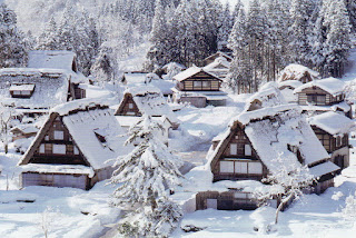
It's kind of hard to distinguish the villages of Shirakawa-go and Gokayama in the postcards if they have nothing written. These historical villages are very look alike because of its typical houses. 

Shirakawa-go
This postcard was sent by Hiro

Shirakawa is a mountain village located at the highest peak on Mount Haku in the Ryōhaku Mountains, where it borders Ishikawa prefecture.
Shirakawa is a leading area of heavy snowfall in the world, and due to this climate, gasshō-zukuri (合掌造り) homes were created. Gassho-zukuri settlements are registered as cultural heritage sites. With the shape of the Hakusan National Park mountain ranges as a background, these sites are major tourist attractions. - in: wikipedia


Shirakawa-go
This postcard was sent by Jennifer

Due to the income from the tourists who came to see the gassho-zukuri villages, the financial condition was greatly improved. Although the area was famous as a tourist site, once it became a UNESCO site, the area greatly grew as tourists visited. Although this success from tourism helped the income of the area, on the other hand, there was an outbreak of damage to the area from tourists entering people's homes to see how they lived, taking pictures and other such manners. in: wikipedia

Gokayama
This postcard was sent by Kazumi

Gokayama is an area within the city of Nanto in Toyama Prefecture, Japan. It has been inscribed on the UNESCO World Heritage List due to its traditional gasshō-zukuri houses, alongside nearby Shirakawa-gō in Gifu Prefecture. The survival of this traditional architectural style is attributed to the region's secluded location in the upper reaches of the Shōgawa river. This is also the reason that Gokayama's lifestyle and culture remained very traditional for many years after the majority of the country had modernized. Many of the houses easily surpass 300 years in age. - in: wikipedia


Sacred Sites and Pilgrimage Routes in the Kii Mountain Range

This site includes several temples, shrines, pilgrimage routes and some nature scenery such as rivers, forests and waterfalls

Mikumari Shrine
This postcard was sent by Ai

Yoshino Mikumari Shrine is a Shinto shrine located on Mount Yoshino in Yoshino districtNaraJapan.
The Shrine is dedicated to mikumari, a female Shinto kami associated with water, fertility and safe birth. Yoshino Mikumari Shrine is one of four important mikumari shrines in the former province Yamato. 
The presents day buildings go back to 1605, when Toyotomi Hideyori rebuilt the shrine, as his father Toyotomi Hideyoshi once had prayed here for a son and successor. - in: wikipedia

Seiganto-ji and Nachi Falls
This postcard was sent by Phoebe

Seiganto-ji, Temple of the Blue Waves, is a Tendai Buddhist temple in Wakayama PrefectureJapan.
According to a legend, it was founded by the priest Ragyō Shōnin, a monk from India. The temple was purposely built near Nachi Falls, where it may have previously been a site of nature worship.

Nachi Falls in NachikatsuuraWakayama PrefectureJapan, is one of the best-known waterfalls in Japan. With a drop of 133 meters (and 13 meters wide), it is the country's tallest water fall with single uninterrupted drop; however, the tallest waterfalls with multiple drops in Japan are Hannoki Falls, at 497 m (seasonal), and Shomyo Falls, at 350m (year round). - in: wikipedia

Okunoin
This postcard was sent by Claus

Kōyasan chōishi-michi is a twenty-four kilometre path with a stone marker (ishi) every 109 metres (chō) leading to KōyasanWakayama PrefectureJapan. Created by Kūkai and within the Kōyasan Chōishi-michi Tamagawa Prefectural Park, it forms part of the UNESCO World Heritage SiteSacred Sites and Pilgrimage Routes in the Kii Mountain Range.
The path leads from Jison-in at the foot of Mount Kōya to Danjō Garan, a distance of just under twenty kilometres (one hundred and eighty markers). It is a further four kilometres to Kūkai's mausoleum in the Okunoin (thirty-six markers). - in: wikipedia

Hiraizumi – Temples, Gardens and Archaeological Sites Representing the Buddhist Pure Land

This was my first postcard from Japan and arrived through Postcrossing. I was extremely happy when I received it because it's not the most popular site of Japan. This property is a group of five sites

Chūson-ji
This postcard was sent by Toshio

Chūson-ji is a Buddhist temple in HiraizumiIwate PrefectureJapan. It is the head temple of the Tendai sect in Tōhoku (northeastern Japan). The Tendai sect claims that the temple was founded in 850 by Ennin, the third chief abbot of the sect.
The Konjiki-dō or 'Golden Hall' is a mausoleum containing the mummified remains of the leaders of the Northern Fujiwara clan who ruled much of northern Japan in the 12th century. It is one of two buildings that survive from the original Chūson-ji temple complex, the other being a sutra repository. - in: wikipedia

The five sites (in red what I have):
  • Chūson-ji
  • Mōtsū-ji
  • Kanjizaiō-in Ato
  • Muryōkō-in Ato
  • Mount Kinkeisan

Monday 20 March 2017

West Lake Cultural Landscape of Hangzhou

The West Lake is a freshwater lake where there are numerous temples, pagodas, gardens and artificial islands.  This lake inspired poets and painters and influenced other gardens in the rest of China, Japan and Korea 

Broken Bridge
This postcard was sent by San-Aiolia

Broken Bridge, located in the eastern end of the Bai Causeway in Hangzhou West Lake, is the most well known bridge among numerous big or small ancient and modern bridges in the West Lake.
It is said that as early as in the Tang Dynasty, this bridge was built. The existing bridge is a arched stone bridge built in 1921 which is 8.8 meters in length and 8.6 meters in width. Though it went through heavy repair, its simple and elegant style is still essentially unchanged. - in: http://www.topchinatravel.com/china-attractions/broken-bridge.htm


Leifeng Pagoda

Leifeng Pagoda is a five-storey tower with eight sides, located on Sunset Hill south of the West Lake in Hangzhou, China. Originally constructed in the year AD 975, it collapsed in 1924 but was rebuilt in 2002. Since then it has been a popular tourist attraction. - in: wikipedia

Kaiping Diaolou and Villages

This UNESCO site, with beautiful towers, comprises four villages. So far I have two postcards but both of the same village

Zili Village
This postcard was sent by Bosen

Diaolous are fortified multi-storey watchtowers, generally made of reinforced concrete. These towers are located mainly in Kaiping County, Guangdong province, China.
The first towers were built during the Ming Dynasty, reaching a peak in the 1920s and 1930s, when there were more than three thousand of these structures.

Zili Village
This postcard was sent by Yunshui

Today, approximately 1,833 diaolou remain standing in Kaiping, and approximately 500 in Taishan. They can also occasionally be found in numerous other areas of Guangdong, such as Shenzhen and Dongguan. Although the diaolou served mainly as protection against forays by bandits, a few of them also served as living quarters.
Kaiping has traditionally been a region of major emigration abroad, and a melting pot of ideas and trends brought back by overseas Chinese. As a result, many diaolou incorporate architectural features from China and from the West. - in: wikipedia

The four villages (in red what I have):


  • Yinglong Lou (at Sanmenli Village)
  • Zili Village and the Fang Clan Watch Tower
  • Majianlong Village Cluster
  • Jingjiangli Village

Zuojiang Huashan Rock Art Cultural Landscape

This is one of the postcards that arrived in worst shape to my mailbox. It even has an apologize message of the Swiss Post Service. Fortunately the sender was very kind and sent me another card that arrived in good condition

Huashan Rock Art
This postcard was sent by Chenzhan

Zuojiang Huashan Rock Art Cultural Landscape are an extensive assembly of historical rock art that were painted on limestone cliff faces in Guangxi, southern China over a period of several hundred years at least. The paintings are located on the west bank of the Ming River which is a tributary of the Zuo River.
The main painted area along the cliff has a width of about 170 metres (560 ft) and a height of about 40 metres (130 ft) and is one of the largest rock paintings in China. 

Huashan Rock Art
This postcard was sent by Chenzhan

The paintings are believed to be between 1800 and 2500 or between 1600 and 2400 years old. The period of their creations hence spans the times from the Warring States period to the late Han Dynasty in the history of China. Many of the paintings are thought to "illustrate the life and rituals" of the ancient Luo Yue people, who are believed to be ancestors of the present-day Zhuang people and inhabited the valley of Zuo River during this period. However, recent carbon dating suggests that the oldest paintings were executed around 16,000 years ago whereas the youngest are around 690 years old. - in: wikipedia

Thursday 16 March 2017

Wadi Rum Protected Area

Wadi Rum, also known as the Valley of the Moon, was used as a background setting in several films like Lawrence of ArabiaRed Planet and The Martian 

This postcard was sent by Steffi

The 74,000-hectare property, inscribed as a mixed natural and cultural site, is situated in southern Jordan, near the border with Saudi Arabia. It features a varied desert landscape consisting of a range of narrow gorges, natural arches, towering cliffs, ramps, massive landslides and caverns. Petroglyphs, inscriptions and archaeological remains in the site testify to 12,000 years of human occupation and interaction with the natural environment. The combination of 25,000 rock carvings with 20,000 inscriptions trace the evolution of human thought and the early development of the alphabet. The site illustrates the evolution of pastoral, agricultural and urban activity in the region. - in: http://whc.unesco.org/en/list/1377/

Landscape of Grand Pré

Grand Pré was made famous by Henry Wadsworth Longfellow's poem Evangeline, about a girl who search her love lost in the expulsion of the Acadians

Grand Pré
This postcard was sent by CJ

Grand-Pré is a Canadian rural community in Kings CountyNova Scotia. Its French name translates to "Great/Large Meadow" and the community lies at the eastern edge of the Annapolis Valley several kilometres east of the town of Wolfville on a peninsula jutting into the Minas Basin surrounded by extensive dyked farm fields, framed by the Gaspereau and Cornwallis Rivers.
Grand-Pré was founded in about 1680 by Pierre Mellanson, an Acadian settler who traveled east from Pierre Dugua, Sieur de Mons's original settlement at Port-Royal.
During the French and Indian War (the North American theatre of the Seven Years' War), the Acadians were expelled from Grand-Pré during the Bay of Fundy Campaign (1755).
Acadians from Grand Pré were dispersed in many locations and some eventually returned to other parts of the Canadian Maritimes such as Nova Scotia, Newfoundland and New Brunswick. Many Acadians expelled from the Grand Pré area eventually settled in the New England States and travelling overland to South Louisiana in the United States after being dropped on the Atlantic coast.
After the deportation of the Acadians, the vacant lands were resettled by New England Planters in 1760 and renamed Horton Township. in: wikipedia