Wednesday 29 June 2016

Historic Centre of Macao

Macao is a former Portuguese colony where a unique assimilation and co-existence of Chinese and Portuguese cultures can be found

Ruins of St. Paul's
This postcard arrived from Russia sent by Elena

The Ruins of St. Paul's are the ruins of a 16th-century complex in Macau including what was originally St. Paul's College and the Church of St. Paul also known as "Mater Dei", a 17th-century Portuguese church dedicated to Saint Paul the Apostle. Today, the ruins are one of Macau's best known landmarks. They are often, but incorrectly, mentioned as a former cathedral (see Macau Cathedral), a status they never had.
Built from 1602 to 1640 by the Jesuits, the collegiate was one of the largest Catholic churches in Asia at the time, and the royalty of Europe vied with each other to bestow upon the temple the best gifts. - in: wikipedia


Brimstone Hill Fortress National Park

This Caribbean fortress testified many battles between British and French for the possession of this territory

Brimstone Hill Fortress
This postcard was sent by Shinta

Brimstone Hill Fortress National Park is a remarkable example of European military engineering dating from the 17th and 18th centuries in a Caribbean context. Located on the Island of St. Christopher (St. Kitts) the country’s largest island, the fortress was built to African slave labour to the exacting standards of the British military to protect the coastline from a sea attack and to provide a safe refuge for the island’s citizens. The engineers, who designed the fort, made use of the natural topography of this double-peaked, steep volcanic hill rising 230 metres.
St. Christopher (St. Kitts) as the first West Indian Island to be colonized by Europeans, specifically the French and English, was the scene of many battles in the struggle for dominance in this region. The earliest use of Brimstone Hill for European military purposes was in 1690 when the British installed a canon to drive out the French. The fortress evolved over the next century and served until 1853 when the British military abandoned it and dismantled many of the buildings. - in: http://whc.unesco.org/en/list/910

Sunday 26 June 2016

Pitons Management Area

This is the only UNESCO site of Saint Lucia, but is only one of the many of the Caribbean

Pitons
This postcard arrived from Indonesia sent by Shinta

The 2,909-ha site near the town of Soufriere includes the Pitons, two volcanic spires rising side by side from the sea (770 m and 743 m high respectively), linked by the Piton Mitan ridge. The volcanic complex includes a geothermal field with sulphurous fumeroles and hot springs. Coral reefs cover almost 60% of the site’s marine area. A survey has revealed 168 species of finfish, 60 species of cnidaria, including corals, eight molluscs, 14 sponges, 11 echinoderms, 15 arthropods and eight annelid worms. The dominant terrestrial vegetation is tropical moist forest grading to subtropical wet forest, with small areas of dry forest and wet elfin woodland on the summits. At least 148 plant species have been recorded on Gros Piton, 97 on Petit Piton and the intervening ridge, among them eight rare tree species. The Gros Piton is home to some 27 bird species (five of them endemic), three indigenous rodents, one opossum, three bats, eight reptiles and three amphibians. - in: http://whc.unesco.org/en/list/1161

Friday 24 June 2016

San Pedro de la Roca Castle, Santiago de Cuba

If this fortress could talk it would tell the most amazing stories about pirates and not only!

San Pedro de la Roca Castle
This postcard arrived from Spain sent by Patricia

The Castillo de San Pedro de la Roca (also known by the less formal title of Castillo del Morro or as San Pedro de la Roca Castle) is a fortress on the coast of the Cuban city of Santiago de Cuba.
It was designed in 1637 by Giovanni Battista Antonelli (also known as Juan Battista Antonelli), a member of a Milanese family of military engineers, on behalf of the governor of the city, Pedro de la Roca de Borja, as a defense against raiding pirates, although an earlier, smaller, fortification had been built between 1590 and 1610.
The fear of pirate attacks was well-founded. While the fortress was still being constructed in 1662, English freebooters under the guidance of Christopher Myngs took control of Santiago for two weeks and during their stay destroyed part of the fortification and captured the artillery. After they departed, the Spanish government ordered the reconstruction of the damaged part of the fortress and raised the garrison to 300 men. Between 1663 and 1669 the engineers Juan Císcara IbáñezJuan Císcara Ramirez and Francisco Perez worked on repairing the damage and improving the fortifications, strengthening the flanks and constructing a new artillery platform. - in: wikipedia

Villa d'Este, Tivoli

The gardens of Villa d'Este are amazing! I wonder if there's still somebody making gardens like this nowadays...

Le Peschiere in Villa d'Este
This postcard arrived from Germany sent by Gaby

The Villa d'Este in Tivoli, with its palace and garden, is one of the most remarkable and comprehensive illustrations of Renaissance culture at its most refined. Its innovative design along with the architectural components in the garden (fountains, ornamental basins, etc.) make this a unique example of an Italian 16th-century garden. The Villa d'Este, one of the first giardini delle meraviglie , was an early model for the development of European gardens. - in: http://whc.unesco.org/en/list/1025

Arab-Norman Palermo and the Cathedral Churches of Cefalú and Monreale

This site includes a series of nine civil and religious structures  that are just a sample (and what a sample!) of the many great things that can be seen in Sicily


Palermo Cathedral
This postcard was sent by Gabi

Palermo Cathedral is the cathedral church of the Roman Catholic Archdiocese of Palermo, located in PalermoSicily, southern Italy. As an architectural complex, it is characterized by the presence of different styles, due to a long history of additions, alterations and restorations, the last of which occurred in the 18th century.
The church was erected in 1185 by Walter Ophamil (or Walter of the Mill), the Anglo-Norman archbishop of Palermo and King William II's minister, on the area of an earlier Byzantine basilica. - in: wikipedia

Cefalù Cathedral
This postcard was sent by Gabi

The Cathedral-Basilica of Cefalù, (ItalianDuomo di Cefalù) is a Roman Catholic church in CefalùSicilyItaly.
The cathedral, dating from 1131, was commenced in the Norman style, the island of Sicily having been conquered by the Normans in 1091. According to tradition, the building was erected after a vow made to the Holy Saviour by the King of Sicily, Roger II, after he escaped from a storm to land on the city's beach. The fortress-like character of the building, which, seen from a distance, rises as a huge bulk above its medieval town. It also made a powerful statement of the Norman presence. in: wikipeida

Mosaics in the Cathedral of Monreale
This postcard was sent by Cristina

The cathedral of Monreale is one of the greatest extant examples of Norman architecture in the world. It was begun in 1174 by William II, and in 1182 the church, dedicated to the Assumption of the Virgin Mary, was, by a bull of Pope Lucius III, elevated to the rank of a metropolitan cathedral.
The church is a national monument of Italy and one of the most important attractions of Sicily. - in: wikipedia

These are the 9 buildings inscribed in this site (in red what I have):
  • Royal Palace and Palatine Chapel
  • Church of San Giovanni degli Eremiti
  • Church of Santa Maria dell’Ammiraglio
  • Church of San Cataldo
  • Palermo Cathedral
  • Zisa Palace
  • Admiral’s Bridge
  • Cefalù Cathedral
  • Monreale Cathedral

Isole Eolie (Aeolian Islands)

Gabi from Germany visited recently two of the Aeolian Islands in Italy: Vulcano and Lipari. When she returned she sent me these two amazing postcards

Vulcano Island

Vulcano (SicilianVurcanu) is a small volcanic island in the Tyrrhenian Sea, about 25 km (16 mi) north of Sicily and the southernmost of the eight Aeolian Islands. It is 21 km2 (8 sq mi) in area, rises to 499 m (1,637 ft) above sea level, and contains several volcanic centers, including one of four active non-submarine volcanoes in Italy.
The Romans used the island mainly for raw materials, harvesting wood and mining alum and sulfur. This was the principal activity on the island until the end of the 19th Century.
Currently, around 470 people live on the island, mainly deriving their income from tourism. It is a few minutes hydrofoil ride from Lipari and has several hotels and cafes, the important attractions being the beaches, hot springs and sulfur mud baths. - in: wikipedia


Lipari
Lipari is the largest of the Aeolian Islands in the Tyrrhenian Sea off the northern coast of Sicily, southern Italy; it is also the name of the island's main town. Its population is 11,231, but during the May to September tourist season, the total population may reach up to 20,000.
Geologists agree on the fact that Lipari was created by a succession of four volcanic movements, the most important of which was the third one, presumably lasting from 20,000 BC to 13,000 BC. A further important phenomenon should have happened around 9000 BC. The last recorded eruptions occurred in the fifth century CE when airborne pumice, together with volcanic ash, covered the Roman villages of the island. The volcanoes are considered active, and steaming fumaroles and hydrothermal activity may still be seen. As a result of its volcanic origin, the island is covered with pumice and obsidian. Pumice mining has become a large industry on Lipari, and the pale pumice from Lipari is shipped worldwide. - in: wikipedia


Tuesday 21 June 2016

Droogmakerij de Beemster (Beemster Polder)

Beemster Polder is one of the best examples of how to make land out of water

Beemster Polder
This postcard was sent by Moniek

The Beemster Polder is a cultural landscape located north of Amsterdam, dating from the early 17th century, and an exceptional example of reclaimed land in the Netherlands. It was created by the draining of Lake Beemster in 1612, in order to develop new agricultural land and space for country residences, and to combat flooding in this low-lying region. It also provided a means for capital investment in land. Other earlier land reclamation had taken place, but technical improvements in windmill technology permitted more ambitious undertakings. The Beemster Polder was the first large project covering an area of 7,208 hectares. Today it is a well-ordered agricultural landscape of fields, roads, canals, dykes and settlements. - in: http://whc.unesco.org/en/list/899

Sunday 19 June 2016

Schokland and Surroundings

"God created the earth, but the Dutch created the Netherlands." This interesting saying represents well the struggle of the people of Schokland 

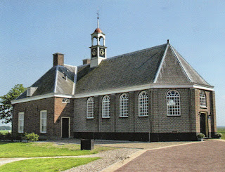
Schokland Church/Museum
This postcard was sent by Ischa

Schokland was a peninsula that by the 15th century had become an island. Occupied and then abandoned as the sea encroached, it had to be evacuated in 1859. But following the draining of the Zuider Zee, it has, since the 1940s, formed part of the land reclaimed from the sea. Schokland has vestiges of human habitation going back to prehistoric times. It symbolizes the heroic, age-old struggle of the people of the Netherlands against the encroachment of the waters. - in: http://whc.unesco.org/en/list/739

Thursday 16 June 2016

Monarch Butterfly Biosphere Reserve

I would say that this place is a sea of butterflies! 

Monarch Butterflies in the mountains of Angangueo
 The 56,259 ha biosphere lies within rugged forested mountains about 100 km northwest of Mexico City. Every autumn, millions, perhaps a billion, butterflies from wide areas of North America return to the site and cluster on small areas of the forest reserve, colouring its trees orange and literally bending their branches under their collective weight. In the spring, these butterflies begin an 8 month migration that takes them all the way to Eastern Canada and back, during which time four successive generations are born and die. How they find their way back to their overwintering site remains a mystery. - in: http://whc.unesco.org/en/list/1290


Mating of the Monarch in the Michoacan Forest
The monarch butterfly or simply monarch (Danaus plexippus) is a milkweed butterfly (subfamily Danainae) in the family Nymphalidae. (...) Its wings feature an easily recognizable black, orange, and white pattern, with a wingspan of 8.9–10.2 cm (3½–4 in).
The eastern North American monarch population is notable for its annual southward late-summer/autumn migration from the United States and southern Canada to Mexico. During the fall migration, monarchs cover thousands of miles, with a corresponding multi-generational return north. The western North American population of monarchs west of the Rocky Mountains often migrates to sites in California but has been found in overwintering Mexican sites as well. Monarchs were transported to the International Space Station and were bred there. - in: wikipedia

Tuesday 14 June 2016

Franciscan Missions in the Sierra Gorda of Querétaro

This site is composed by five Franciscan missions, built during the last phase of the conversion to Christianity of the interior of Mexico. 

Santiago Mission in Jalpan
This postcard was sent by Marco

The Santiago mission in Jalpan was established before the arrival of Junípero Serra in 1744, but Serra was in charge of building the mission complex that stands today from 1751 to 1758, the first to be built. It is dedicated to James the Greater, the first evangelist. This complex is situated in the center of the modern town in front of the main plaza and formed by an atriumcloister, pilgrim portal and church, with a chapel annex on the left side. The original atrium wall was lost, but reconstructed in the same style, with three portals and inverted arches. The main features of the ornate portal on the facade are Our Lady of the Pillar and the Virgin of Guadalupe, both with Mesoamerican connections, as well as a double headed eagle, meant to symbolize the blending of the two cultures. - in: wikipedia


Mission of Nuestra Señora de la Luz
This postcard was sent by Marco

(...) mission is located in the community of Tancoyol called Nuestra Señora de la Luz de Tancoyol, dedicated to Our Lady of Light. This facade has profuse vegetative ornamentation, with ears of corn prominent and is the most elaborate of the five missions. It is likely that this mission was constructed by Juan Ramos de Lora, who resided here from 1761 to 1767. The structure is similar to those in Jalpan and Landa. (...) The interior has a number of sculptures including one of “Our Lady of Light.” The facade is marked by a rhomboid window surrounded by a representation of the cord Franciscans use to tie their habits. The basic theme of the facade is mercy, represented by interventions by the Virgin Mary and various saints. The iconography of this portal is the most elaborate of the five missions. Indigenous elements are found in the church’s interior, with an image of a jaguar and a person with Olmec features. - in: wkipedia


The five missions (in red what I have):

  • Santiago mission in Jalpan
  • Santa María del Agua de Landa
  • San Francisco del Valle de Tilaco
  • Nuestra Señora de la Luz de Tancoyo
  • San Miguel Concá

Historic Centre of Puebla

Puebla is one of the most important Spanish colonial cities in Mexico and is located at the foot of the Popocatepetl volcano. Seems to be a very beautiful city!
These two postcards were sent by Marco

Puebla City Hall
 Since the founding of the City in 1531, this building was allocated as the Town Hall or City Hall, and it is said that here is where"the authorities were brought together for that which was needed". The original building suffered damage several times, and in 1704 it was demolished and rebuilt with a graceful two-story archway. By 1897, a new project was commissioned to English architect Charles T.S. Hall who used an Elizabethan English design, with that work concluding in 1906. Noteworthy is the elegant courtyard with a double archway, the majestic marble staircase, the allegorical stained glass scenes of the city, and especially the great hall of Councils in a renaissance style which holds paintings by artist Henry Gutierrez. There is where the two royal credentials are housed: the one that gives the title of the City ‘Puebla de Los Angeles,’ and the other that gives it its own coat of arms. In the facade, a replica of the "San Jose Bell" can be seen, which was a gift from the then President of the Republic, Adolfo López Mateos, which is tolled every September 15, during the ceremony of the "Grito de Independencia". This building currently serves as City Hall. - in: https://www.travelbymexico.com/puebla/atractivos/index2.php?nom=epuepalgob

Puebla Cathedral
The Catedral Basílica is dedicated to the Immaculate Conception of Mary. The original cathedral was located in what is now the atrium. The Church that we see today,  was started in 1575 according to the ‘working drawing’ of Juan de Cigorondo and Francisco Becerra, and it boasts a clearly Renaissance style with Baroque ornamentation. The north tower where the bells were placed, was completed in 1678, and the south tower in 1768. The main facade was completed in 1664, and has three portals   The central doorway elegantly shows the shield of  the Spanish crown, the Marian monogram, and the patrons St John, St. James and St. Peter and Paul.  The side entryways display reliefs of Santa Rosa of Lima and St. Teresa of Avila. Inside, the choir with its pews is noteworthy, as well as the organs and the monumental gate. The cypress and  neoclassical altar were designed by Manuel Tolsa and built by Joseph Manzo. The Kings’ Altar, by artist Pedro Garcia Ferrer, is a leading example of baroque from the 17th century. The Church was consecrated on April 18, 1649, by the main propeller of its conclusion, Bishop Don Juan de Palafox y Mendoza. The Basilica Cathedral of the city of Puebla is located next to the Zocalo. - inhttps://www.travelbymexico.com/puebla/atractivos/index2.php?nom=epuecatedral&don=20

Monday 13 June 2016

Port, Fortresses and Group of Monuments, Cartagena

I really like this postcard! A perfect marriage between the military and the religious. Cartagena looks very beautiful

Minaret and San Pedro Claver Church
This postcard was sent by Claus

The Church of San Pedro Claver is a Colombian Catholic cult temple dedicated to San Pedro Claver, whose remains are in the church's altar. It is located on the corner of Calle 31 with Carrera 4, right in front of the Plaza de la Aduana, in the historic part of the city of Cartagena de Indias. 
The temple is part of a set of religious buildings which is complemented by the Cloister of San Pedro Claver and the archaeological museum. It was built between 1580 and 1654, under the parameters of the colonial buildings. It was originally known as Church of San Juan de Dios, from 1622 it was called church of San Ignacio de Loyola and now called San Pedro Claver. - in: wikipedia


National Archeological Park of Tierradentro

It's very curious to see how different can tombs be from place to place, from era to era, from one civilization to another civilization

National Park of Tierradentro 
This postcard was sent by Claus

Tierradentro is a National archeological park in the jurisdiction of the municipality of InzaDepartmentof CaucaColombia. The park is located 100 km away from the capital of the Department, Popayán.
The area is very well known for its pre-Columbian hypogea, which were found in several excavations, and are divided in many archeological places. some of them are: Alto del Aguacate (Avocado Hill), Alto de San Andrés, Alto de Segovia, Alto del Duende and El Tablón.
The pre-Columbian culture that created this funeral complex inhabited this area during the first millennium A.C. Tierradentro Archaeological park features hypogea dating from 6th to 9th centuries AD. The details in the sculptures and pictoric patterns are similar to the San Agustín culture. - in: wikipedia

Colonial City of Santo Domingo

I already had two or three postcards from Dominican Republic, brought by family and friends, all showing paradise beaches and finally I have two postcards of the only UNESCO site of the country, thanks to Marco!

Museo de las Casas Reales
 The Museo de las Casas Reales (English: Museum of the Royal Houses) is one of the important cultural monuments built during the colonial era in Hispaniola, now the Dominican Republic. It is located in the Colonial district of Santo Domingo.
The building dates back to the sixteenth century, and was built to house the administrative offices of the Spanish colonies in the Americas.
The palace was built by orders of the Spanish Crown, represented by King Ferdinand II of Aragon, on October 5 of 1511 to house the main government offices of the colony in two interconnected buildings.
The original architectural structure has undergone a number of changes through the country's history. - in: wikipedia

National Pantheon
The National Pantheon was built from 1714-1746 by the Spaniard Geronimo Quezada y Garçon and was originally a Jesuit church. The structure was constructed in the neoclassic-renaissance style. Today the structure stands as a national symbol of the Dominican Republic and serves as the final resting place of the Republic's most honored citizens. - in: wikipedia

Sunday 12 June 2016

Mosi-oa-Tunya / Victoria Falls

According to UNESCO these are among the most spectacular waterfalls in the world

Devil's Cataract
This postcard arrived from Canada and it was sent by Jason

The Mosi-oa-Tunya/Victoria Falls is the world’s greatest sheet of falling water and significant worldwide for its exceptional geological and geomorphological features and active land formation processes with outstanding beauty attributed to the falls i.e. the spray, mist and rainbows. This transboundary property extends over 6860 ha and comprises 3779 ha of the Mosi-oa-Tunya National Park (Zambia), 2340 ha of Victoria Falls National Park (Zimbabwe), 741 ha of the riverine strip of Zambezi National Park (Zimbabwe). A riverine strip of the Zambezi National Park extending 9 km west along the right bank of the Zambezi and islands in the river are all within the Park as far as Palm and Kandahar Islands, with the Victoria Falls being one of the major attractions. The waterfall stands at an altitude of about 915 m above mean sea level (a.m.s.l.) and spans to about 1708 m wide with an average depth of 100 m and the deepest point being 108 m. Sprays from this giant waterfall can be seen from a distance of 30 km from the Lusaka road, Zambia and 50 km from Bulawayo road, Zimbabwe. Basalts have been cut by a river system producing a series of eightspectacular gorges that serve as breeding sites for four species of endangered birds. The basalts of the Victoria Falls World Heritage property are layered unlike those of the Giants Causeway World Heritage site which are vertical and columnar. - in: http://whc.unesco.org/en/list/509

I'm still missing a postcard from Zambia

Kunya-Urgench

This archaeological site, that was located in the Silk Road, comprises mosques, the gates of a caravanserai, fortresses, mausoleums and a minaret.

Minaret of Kutlug Timur and Mausoleum of Sultan Tekesh
This postcard was sent by Claus

Kutlug-Timur Minaret: This minaret is perhaps one of the most striking structures which remains standing at the site. It dates back to the 11th and 12th centuries, and it measures 60 meters in height, making it the highest monument in the park. Additionally, its diameter measures 12 meters at the base, and 2 at the top.

On the basis of its decorative brickwork, including Kufic inscriptions, the minaret is thought to be an earlier construction, only restored by Kutlug-Timur around 1330.

Tekesh Mausoleum: This structure is the presumed Tomb of Sultan Ala al-din Tekesh, the founder of the Khwarezm Empire and its ruler between 1172-1200. It has been identified as a mausoleum due to the tradition that each ancient Central Asian building is dedicated to a historical or mythical personage.

The building is made of bricks and consists of a square hall with walls which are 11,45 meters high, a massive round drum and a conical roof with an inner dome hidden under it. The dome is connected to the square walls it rests upon by an octagonal belt. The structure between the dome and the octagon is decorated with 16 shallow niches. - in: wikipedia