Monday 29 August 2016

Dorset and East Devon Coast

The Dorset and East Devon Coast is an important fossil site that covers the TriassicJurassic and Cretaceous periods

Durdle Door, Dorset
This postcard was sent by Lucy

Durdle Door (sometimes written Durdle Dor) is a natural limestone arch on the Jurassic Coast near Lulworth in Dorset, England.
The form of the coastline around Durdle Door is controlled by its geology—both by the contrasting hardnesses of the rocks, and by the local patterns of faults and folds. The arch has formed on a concordant coastline where bands of rock run parallel to the shoreline. The rock strata are almost vertical, and the bands of rock are quite narrow. Originally a band of resistant Portland limestone ran along the shore, the same band that appears one mile along the coast forming the narrow entrance to Lulworth Cove. Behind this is a 120-metre (390 ft) band of weaker, easily eroded rocks, and behind this is a stronger and much thicker band of chalk, which forms the Purbeck Hills. These steeply dipping rocks are part of the geological structure known as the Lulworth crumple, itself part of a broader monocline (a kinked type of geological fold) produced by the building of the Alps during the mid-Cenozoic. in: wikipedia

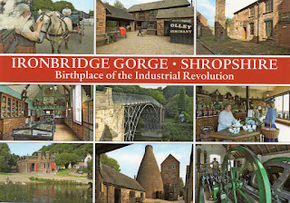
Ironbridge Gorge

Built in 1779, this bridge was the first iron bridge of the world and is connected with the beginning of the industrial revolution 

Ironbridge Gorge
This postcard was sent by Anu

Ironbridge is known throughout the world as the symbol of the Industrial Revolution. It contains all the elements of progress that contributed to the rapid development of this industrial region in the 18th century, from the mines themselves to the railway lines. Nearby, the blast furnace of Coalbrookdale, built in 1708, is a reminder of the discovery of coke. The bridge at Ironbridge, the world's first bridge constructed of iron, had a considerable influence on developments in the fields of technology and architecture. - in: http://whc.unesco.org/en/list/371/

Saturday 27 August 2016

Stevns Klint

This site is one of the places that helps to explain the extinction of dinosaurs 65 million years ago  

Stevns Klint
 This postcard was sent by  Steffi


Stevns Cliff extends over approximately 15 km of coastline and is up to 41 meters in height. Along the sea, the many landslides have left fantastic formations not found elsewhere. The cliffs reveal the geological layers which have accumulated during millions of years. They are rich in fossils and thus present a veritable Eldorado for geology buffs. Stevns Museum has an exhibition focussed on the geology of the cliffs. - in: http://www.stevnsklint.dk/cliff.htm

Stevns Klint
This postcard was sent by Rebekka

This geological site comprises a 15 km-long fossil-rich coastal cliff, offering exceptional evidence of the impact of the Chicxulub meteorite that crashed into the planet at the end of the Cretaceous, about 65 million years ago. Researchers think that this caused the most remarkable mass extinction ever, responsible for the disappearance of over 50 per cent of all life on Earth. The site harbours a record of the cloud of ash formed by the impact of the meteorite – the exact site being at the bottom of the ocean off the coast of Mexico’s Yucatán Peninsula. An exceptional fossil record is visible at the site, showing the complete succession of fauna and micro-fauna charting the recovery after the mass extinction. - in: http://whc.unesco.org/en/list/1416

Tuesday 23 August 2016

Church and Dominican Convent of Santa Maria delle Grazie with “The Last Supper” by Leonardo da Vinci

This site comprises "The Last Supper", the masterpiece of Leonardo da Vinci that inspired books and movies

Church of Santa Maria delle Grazie

This postcard was sent by Claus

The Church of Santa Maria delle Grazie, situated in the heart of Milan, is an outstanding work of architecture, and an emblem within the Catholic tradition. Santa Maria delle Grazie is perhaps even more famous for its indissoluable connection to Leonardo Da Vinci's fresco of “The Last Supper,” preserved inside its refectory (dining hall).
The Church is one of Renaissance art's most important testimonies and a shining symbol of creative human genius -  thus it became a UNESCO World Heritage List in 1980. 


The Last Supper by Leonardo da Vinci

This postcard was sent by Marina

The Last Supper is one of the most recognized and appreciated artistic masterpieces in the world – by Da Vinci and in general – and is the only fresco of its kind still visible today. 
The painting’s theme is that of the Gospel of John, in which Jesus announces that one of his apostles will betray him. 
Da Vinci set the long refectory table at stage center in this room, with Christ at the center of a pyramid formed by extended arms. 
Around Christ the apostles are painted in four groups of three, varied but symmetrically level. The use of perspective and the placement of the personages draws focus to the center of the painting, whence it seems that it is Christ who not only watches over the entire scene, but who seems to be living this decisive moment intensely, and in the very present.
Leonardo da Vinci adopted the technique of layering the fresco (commissioned by Ludovico Sforza) with tempera paint, so that he could be free in his creativity; such has created remarkable problems for the fresco over time, given the dramatic effect that changes in climate can have on it. 
Anglo-American bombers struck the Church and Convent in 1943: while the Refectory was razed to the ground, a few of the structure’s walls survived, including that of the Refectory, as it had been reinforced prior with sandbags. It was saved from the War and remains still today an icon of devotion for Milanese Catholics. - in: http://www.italia.it/en/travel-ideas/unesco-world-heritage-sites/santa-maria-delle-grazie-with-the-last-supper.html

Sunday 21 August 2016

Rideau Canal

The sender of this postcard works right next the Rideau Canal. The canal, built for military purposes and with several fortifications along it, is a place of great fun for locals and tourists.

Rideau Canal
This postcard was sent by Jason

The Rideau Canal, a monumental early 19th-century construction covering 202 km of the Rideau and Cataraqui rivers from Ottawa south to Kingston Harbour on Lake Ontario, was built primarily for strategic military purposes at a time when Great Britain and the United States vied for control of the region. The site, one of the first canals to be designed specifically for steam-powered vessels, also features an ensemble of fortifications. It is the best-preserved example of a slackwater canal in North America, demonstrating the use of this European technology on a large scale. It is the only canal dating from the great North American canal-building era of the early 19th century to remain operational along its original line with most of its structures intact. - in: http://whc.unesco.org/en/list/1221/

Canal du Midi

Two years ago I spent three wonderful days right next to the Canal de la Robine, a branch of the Canal du Midi. It was where I bought all these postcards, except the second one, sent by Ulla.

Map of Canal du Midi
 The Canal du Midi (OccitanCanal de las Doas Mars, meaning canal of the two seas) is a 241 km (150 mi) long canal in Southern France (Frenchle Midi). It was originally named the Canal royal en Languedoc (Royal Canal in Languedoc) but the French revolutionaries renamed it to Canal du Midi in 1789. It was considered at the time to be one of the greatest construction works of the 17th century.


Canal du Midi
The canal connects the Garonne River to the Étang de Thau on the Mediterranean and along with the 193 km (120 mi) long Canal de Garonne forms the Canal des Deux Mers joining the Atlantic to the Mediterranean. The canal runs from the city of Toulouse down to the Étang de Thau near the Mediterranean.

Canal du Midi
 The construction of the canal was motivated by wheat trade. Jean-Baptiste Colbert authorized the commencement of work by a royal edict of October 1666. Under the supervision of Pierre-Paul Riquet the construction took from 1666 to 1681 during the reign of Louis XIV

Canal du Midi

The Canal du Midi is one of the oldest canals of Europe still in operation (the prototype being the Briare Canal). The challenges in these works are closely related to the challenges of river transport today. 

Canal du Midi

The key challenge, raised by Pierre-Paul Riquet, was to convey water from the Montagne Noire (Black Mountains) to the Seuil de Naurouze, the highest point of the canal.


Fonserannes Lock
 Fonserannes Lock (Frenchécluse de Fonserannesles neuf écluses) is a staircase lock on the Canal du Midi near Béziers. It consists of eight ovoid lock chambers (characteristic of the Canal du Midi) and nine gates, which allow boats to be raised a height of 21.5 m, in a distance of 300 m. Whilst the flight was built as an 8-rise, to allow boats to cross the River Orb on a level, rejoining the canal a little further downstream, the crossing of the Orb was long ago replaced by an aqueduct.

Statue of Pierre-Paul Riquet at Béziers and Canal du Midi
Paul Riquet was born in BéziersHéraultFrance, the eldest son of solicitor, state prosecutor and businessman Guillaume Riquet.
Riquet is the man responsible for building the 240-kilometre-long artificial waterway that links the southern coast of France to Toulouse to link to the canal/river system that ran across to the Bay of Biscay, one of the great engineering feats of the 17th century. 
Riquet's major engineering achievements included the Fonserannes Lock Staircase and the Malpas Tunnel, the world's first navigable canal tunnel. The canal was completed in 1681, eight months after Riquet's death. He is buried in the Cathedral Saint-Etienne in Toulouse. - in: wikipedia

Saturday 20 August 2016

Chartres Cathedral

This is one of the many great cathedrals of France, a masterpiece and the high point of French Gothic art

Chartres Cathedral
This postcard was sent by Ulla

Chartres Cathedral, also known as the Cathedral of Our Lady of Chartres (FrenchCathédrale Notre-Dame de Chartres), is a medieval Catholic cathedral of the Latin Church located in Chartres, France, about 80 kilometres (50 mi) southwest of Paris. The current cathedral, mostly constructed between 1194 and 1250, is the last of at least five which have occupied the site since the town became a bishopric in the 4th century.
The cathedral is in an exceptional state of preservation. The majority of the original stained glass windows survive intact, while the architecture has seen only minor changes since the early 13th century. The building's exterior is dominated by heavy flying buttresses which allowed the architects to increase the window size significantly, while the west end is dominated by two contrasting spires – a 105-metre (349 ft) plain pyramid completed around 1160 and a 113-metre (377 ft) early 16th-century Flamboyant spire on top of an older tower. Equally notable are the three great façades, each adorned with hundreds of sculpted figures illustrating key theological themes and narratives. - in: wikipedia

Friday 19 August 2016

Amiens Cathedral

This cathedral must be amazing! Is one of the biggest cathedrals in France

Amiens Cathedral
This postcard was sent by Axel

The Cathedral Basilica of Our Lady of Amiens (FrenchBasilique Cathédrale Notre-Dame d'Amiens), or simply Amiens Cathedral, is a Roman Catholic cathedral and seat of the Bishop of Amiens (currently Jean-Luc Bouilleret). It is situated on a slight ridge overlooking the River Somme in Amiens, the administrative capital of the Picardy region of France, some 120 kilometres (75 miles) north of Paris. It is the 19th largest church in the world.
Medieval cathedral builders were trying to maximize the internal dimensions in order to reach for the heavens and bring in more light. In that regard, the Amiens cathedral is the tallest complete cathedral in France, its stone-vaulted nave reaching an internal height of 42.30 metres (138.8 ft) (surpassed only by the incomplete Beauvais Cathedral). It also has the greatest interior volume of any French cathedral, estimated at 200,000 cubic metres (260,000 cu yd). The cathedral was built between 1220 and c.1270 and has been listed as a UNESCO World Heritage Site since 1981. Although it has lost most of its original stained glass, Amiens Cathedral is renowned for the quality and quantity of early 13th-century Gothic sculpture in the main west façade and the south transept portal, and a large quantity of polychrome sculpture from later periods inside the building. - in: wikipedia

Cathedral of Notre-Dame, Former Abbey of Saint-Rémi and Palace of Tau, Reims

Of the three buildings comprised in this site I only have the Cathedral of Reims, a masterpiece of Gothic art

Notre-Dame de Reims Cathedral
This postcard was sent by Steffi

Notre-Dame de Reims (Our Lady of Reims) is the seat of the Archdiocese of Reims, where the kings of France were crowned. The cathedral replaced an older church, destroyed by fire in 1211, that was built on the site of the basilica where Clovis was baptized by Saint Remibishop of Reims, in AD 496. That original structure had itself been erected on the site of some Roman baths. A major tourism destination, the cathedral receives about one million visitors annually. - in: wikipedia

Thursday 18 August 2016

Luther Memorials in Eisleben and Wittenberg

There are six places in Eisleben and Wittenberg associated with Luther that are listed in the UNESCO World Heritage list. I have two postcards showing three of those places.

Luther's Birthplace and Luther's Death House
This postcard was sent by Katrin

Martin Luther was born in Eisleben on November 10, 1483. Eisleben's residents began to commemorate their city’s most famous son at a very early date; by the end of the seventeenth century, they had already provided Luther pilgrims with a public museum in the house where Luther was born. This makes the museum one of the oldest institutions of its kind in a German-speaking country. The house's present appearance derives from renovation work carried out after the city fire of 1689. - in: http://www.martinluther.de/index.php?lang=en&Itemid=427

Throughout his life, Martin Luther maintained close contact to the Mansfeld district. He visited Eisleben, the town where he was born, on numerous occasions to exert his influence over events. Luther was paying another visit to the town to mediate among the quarrelling local rulers when he died there on February 18, 1546. 

Today, the museum located opposite the Eisleben market commemorates Luther’s death. The house was first named Luther’s Death House in 1726. In 1863, the Prussian treasury acquired the building and established a memorial on the site. - in: http://www.martinluther.de/index.php?lang=en&Itemid=435

All Saints' Church
This postcard was sent by Michèle


All Saints' Church, commonly referred to as Schlosskirche (Castle Church) to distinguish it from the Stadtkirche (Town Church) of St. Mary – and sometimes known as the Reformation Memorial Church – is a Lutheran church in Wittenberg, Germany. It is the site where, according to university custom, the Ninety-Five Theses were posted by Martin Luther on 31 October 1517, the act that has been called the start of the Protestant Reformation. - in: wikipedia

Historic Centre of Mexico City and Xochimilco

Just to see the amazing cathedral of Mexico City it would be already worth it to go to the Mexican capital, but there's a lot more to see! These two postcards were sent by Marco

Zócalo with the Cathedral, Templo Mayor and National Palace
 The Zócalo  is the common name of the main square in central Mexico City. Prior to the colonial period, it was the main ceremonial center in the Aztec city of Tenochtitlan. The plaza used to be known simply as the "Main Square" or "Arms Square," and today its formal name is Plaza de la Constitución (Constitution Square). This name does not come from any of the Mexican constitutions that have governed the country but rather from the Cádiz Constitution which was signed in Spain in the year 1812. However, it is almost always called the Zócalo today. Plans were made to erect a column as a monument to Independence, but only the base, or zócalo (meaning "plinth") was built. The plinth was destroyed long ago but the name has lived on. 

The Metropolitan Cathedral of the Assumption of the Most Blessed Virgin Mary into Heaven (SpanishCatedral Metropolitana de la Asunción de la Santísima Virgen María a los cielos) is the largest cathedral in the Americas, and seat of the Roman Catholic Archdiocese of Mexico. It is situated atop the former Aztec sacred precinct near the Templo Mayor on the northern side of the Plaza de la Constitución in Downtown Mexico City. The cathedral was built in sections from 1573 to 1813 around the original church that was constructed soon after the Spanish conquest of Tenochtitlan, eventually replacing it entirely. Spanish architect Claudio de Arciniega planned the construction, drawing inspiration from Gothic cathedrals in Spain.

The Templo Mayor (Spanish for "Great Temple") was one of the main temples of the Aztecs in their capital city of Tenochtitlan, which is now Mexico City. Its architectural style belongs to the late Postclassic period of Mesoamerica.

The National Palace (Palacio Nacional in Spanish) is the seat of the federal executive in Mexico. It is located on Mexico City's main square, the Plaza de la Constitución (El Zócalo). This site has been a palace for the ruling class of Mexico since the Aztec empire, and much of the current palace's building materials are from the original one that belonged to Moctezuma II. - in: wikipedia

Xochimilco
Xochimilco is one of the 16 delegaciones or boroughs within Mexican Federal District. The borough is centered on the formerly independent city of Xochimilco, which was established on what was the southern shore ofLake Xochimilco in the pre-Hispanic period. Today, the borough consists of the eighteen “barrios” or neighborhoods of this city along with fourteen “pueblos” or villages that surround it, covering an area of 125 km2 (48 sq mi). While the borough is somewhat in the geographic center of the Federal District, it is considered to be “south” and has an identity separate from the historic center of Mexico City. This is due to its historic separation from that city during most of its history. Xochimilco is best known for its canals, which are left from what was an extensive lake and canal system that connected most of the settlements of the Valley of Mexico. These canals, along with artificial islands called chinampas, attract tourists and other city residents to ride on colorful gondola-like boats called “trajineras” around the 170 km (110 mi) of canals. This canal and chinampa system, as a vestige of the area’s pre-Hispanic past, has made Xochimilco a World Heritage Site. - in: wikipedia

Sunday 14 August 2016

Fortifications on the Caribbean Side of Panama: Portobelo-San Lorenzo

Despite these intimidating fortifications, this site was attacked and sacked several times. The gold and silver called the attention of pirates who made of this place an intense battle field

Fortification in Portobelo
 The Fortifications on the Caribbean side of Panamá: Portobelo and San Lorenzo are located along the coast of the Province of Colón. There are diverse fortification sites around the Bay of Portobelo, denominated San Fernando fortifications: Lower Battery, Upper Battery and Hilltop Stronghold; San Jerónimo Battery Fort; Santiago fortifications: Castle of Santiago de la Gloria, Battery and Hilltop Stronghold; the old Santiago Fortress; ruins of Fort Farnese; the La Trinchera site; the Buenaventura Battery; and the San Cristóbal site. Forty-three kilometers away, at the mouth the Chagres River stands the San Lorenzo Castle (originally “San Lorenzo el Real del Chagre”) with its Upper Battery as a separate structure. 

Fortification in Portobelo

The town of San Felipe de Portobelo was founded in March 20th, 1597, as a Caribbean Terminal of the trail through the Isthmus of Panama, to replace Nombre de Dios as a port of transit and trans-shipment. The need to ease the overland path along the Isthmus during the rainy season called for an alternative route. The Chagres River-Cruces path, a mixed fluvial and land trail, was the counterpart of Camino Real from Panama City to Portobelo, built as a response to this need. - in: http://whc.unesco.org/en/list/135/