Saturday 24 March 2018

Mill Network at Kinderdijk-Elshout

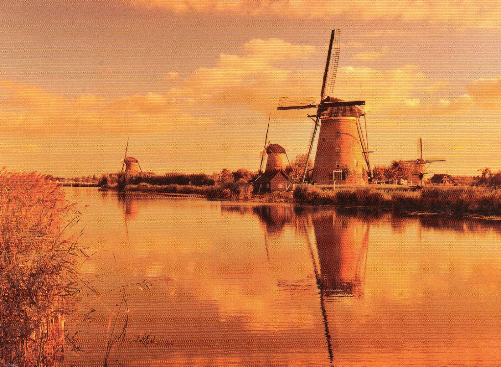
The windmills of Kinderdijk are one of the best-known Dutch tourist sites and I hope to go there one day.

Kinderdijk
This postcard was sent by Kim

The windmills at Kinderdijk are a group of 19 monumental windmills in the Alblasserwaard polder, in the province of South HollandNetherlands. Most of the mills are part of the village of Kinderdijk in the municipality of Molenwaard, and one mill, De Blokker, is part of the municipality of Alblasserdam. Built in 1738 and 1740, to keep water out of the polder, it is the largest concentration of old windmills in the Netherlands and one of the best-known Dutch tourist sites. The mills are listed as national monuments and the entire area is a protected village view since 1993. They have been a UNESCO World Heritage Site since 1997. 


Kinderdijk

This postcard was sent by Christel

Kinderdijk lies in the Alblasserwaard, at the confluence of the Lek and Noord rivers. In Alblasserwaard, problems with water became more and more apparent in the 13th century. Large canals, called "weteringen", were dug to get rid of the excess water in the polders. However, the drained soil started setting, while the level of the river rose due to the river's sand deposits. 

Kinderdijk

This postcard was sent by Diana

After a few centuries, an additional way to keep the polders dry was required. It was decided to build a series of windmills, with a limited capacity to bridge water level differences, but just able to pump water into a reservoir at an intermediate level between the soil in the polder and the river; the reservoir could be pumped out into the river by other windmills whenever the river level was low enough; the river level has both seasonal and tidal variations. Although some of the windmills are still used, the main water works are provided by two diesel pumping stations near one of the entrances of the windmills site.

Kinderdijk
This postcard was sent by Astrid

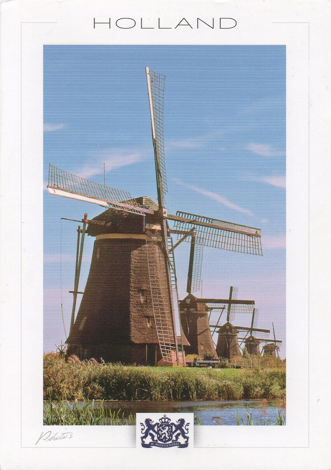
Most of the current mills were built in 1738 and 1740, and form two stairways of 8 mills each to pump water to a higher level every time it reaches the next mill in line. - in: wikipedia

Kinderdijk
This postcard was sent by Joyce


Wednesday 21 March 2018

La Chaux-de-Fonds / Le Locle, Watchmaking Town Planning

Another UNESCO site that we visited after moving to Switzerland was La Chaux-de-Fonds where the highest point was the visit to the International Museum of Horology. Some of the most amazing devices to measure the time can be found here and a lot of them made in La Chaux-de-Fonds and Le Locle.
The cards of La Chaux-de-Fonds show pieces of art of the museum's collection.

Building of control of works in precious metals, Synagogue and golden watch by Paul Ditisheim, style "Art Nouveau", 1901 

The site of La Chaux-de-Fonds / Le Locle watchmaking town-planning consists of two towns situated close to one another in a remote environment in the Swiss Jura mountains, on land ill-suited to farming. Their planning and buildings reflect watchmakers’ need of rational organization. Planned in the early 19th century, after extensive fires, the towns owed their existence to this single industry. Their layout along an open-ended scheme of parallel strips on which residential housing and workshops are intermingled reflects the needs of the local watchmaking culture that dates to the 17th century and is still alive today.

Masonic Lodge "L'Amitié" and Waltham triangular wristwatch, dial with Masonic symbols, 1960 
The site presents outstanding examples of mono-industrial manufacturing-towns which are well preserved and still active. The urban planning of both towns has accommodated the transition from the artisanal production of a cottage industry to the more concentrated factory production of the late 19th and 20th centuries. The town of La Chaux-de-Fonds was described by Karl Marx as a “huge factory-town” in Das Kapital where he analyzed the division of labour in the watchmaking industry of the Jura. - in: http://whc.unesco.org/en/list/1302


Musée International d'Horologie and regulator with calendar by Robert Robin, 1796
In 1865 the Watchmaking School of La Chaux-de-Fonds had the idea of putting together a collection of old clocks. This resulted, in 1902, in the opening of a small museum in the same building as the school. The collection gradually grew and the museum was enlarged three times, in 1907, 1952 and 1967.
It finally became clear that the premises were no longer suitable for a permanent and functional display of the whole collection. The Committee of the Museum therefore suggested to the Municipality of La Chaux-de-Fonds that a foundation should be set up with the purpose of promoting the construction of a new building. Opened in 1974 under the name of Musée international d'horlogerie, this was characterized by a conception and techniques in the avant-garde of architecture and museography. Three decades later its construction is as fascinating as its exhibits. - in: wikipedia

Le Locle
This postcard was sent by Steffi

Le Locle is a municipality in Le Locle District in the Canton of Neuchâtel in Switzerland. It is situated in the Jura Mountains, a few kilometers from the city of La Chaux-de-Fonds.
Le Locle is known as a center of Swiss watchmaking, even cited as the birthplace of the industry, with roots dating back to the 1600s.
The town's history in watchmaking is documented at one of the world's premier horological museums, the Musée d'Horlogerie du LocleMonts Castle, located in a 19th-century country manor on a hill north of the city. - in: wikipedia

Three Castles, Defensive Wall and Ramparts of the Market-Town of Bellinzona

In 2014 my wife and I went to Lugano and, in the way, we stopped in Bellinzona. It was a very short stop. I hope to go there again to do a proper visit.

Old Poster of Bellinzona
The Castles of Bellinzona are a group of fortifications located around the town of Bellinzona, the capital of the Swiss canton of Ticino. Situated on the Alpine foothills, the group is composed of fortified walls and three castles named CastelgrandeMontebello and Sasso CorbaroCastelgrande is located on a rocky peak overlooking the valley, with a series of walls that protect the old city and connect to Montebello. Sasso Corbaro, the highest of the three castles, is located on an isolated rocky promontory south-east of the other two. 

Castelgrande
The site of Castelgrande has been fortified since at least the late 1st century BC and until the 13th century it was the only fortification in Bellinzona. During its history the castle has been known as the stronghold (before the 13th century), the Old Castle in the 14–15th centuries, Un Castle after 1506 and Saint Michael's Castle from 1818.


White Tower of Castelgrande

In the center of the keep is the tallest tower of Castelgrande, the Torre Bianca or White Tower, which dates from the 13th century. Surrounding the Torre Bianca is the palace of the Bishop of Como (mentioned in the 12th century), which may contain masonry from an earlier 10th or 11th century structure. - in: wikipedia

Montebello Castle
This postcard was sent by Steffi

Montebello Castle (known as the Small, New or Middle Castle in the 15th century, as Schwyz Castle from 1506 and St. Martin's Castle after 1818) is located to the east of the town center. It was built before 1313 for the pro-Imperial Rusca family, who occupied the castle following the Visconti victory and occupation of Castelgrande. By the end of the 14th century it was in the hands of the Visconti. The castle was renovated and expanded between 1462 and 1490 to its current state. In the 19th century the castle fell into disrepair and was renovated starting in 1903. - in: wikipedia

Tuesday 13 March 2018

Le Morne Cultural Landscape

This beautiful postcard was a great surprise in my mailbox! Completely unexpected!

Le Morne


Le Morne Cultural Landscape, a rugged mountain that juts into the Indian Ocean in the southwest of Mauritius was used as a shelter by runaway slaves, maroons, through the 18th and early years of the 19th centuries. Protected by the mountain’s isolated, wooded and almost inaccessible cliffs, the escaped slaves formed small settlements in the caves and on the summit of Le Morne. The oral traditions associated with the maroons, have made Le Morne a symbol of the slaves’ fight for freedom, their suffering, and their sacrifice, all of which have relevance to the countries from which the slaves came - the African mainland, Madagascar, India, and South-east Asia. Indeed, Mauritius, an important stopover in the eastern slave trade, also came to be known as the “Maroon republic” because of the large number of escaped slaves who lived on Le Morne Mountain. - in: http://whc.unesco.org/en/list/1259

Sunday 11 March 2018

Cultural Sites of Al Ain (Hafit, Hili, Bidaa Bint Saud and Oases Areas)

Heidi from Finland visited recently the United Arab Emirates from where she sent me this postcard. This site includes remains of circular stone tombs and settlements from the Hafit and Hili periods, wells and partially underground aflaj irrigation systems, oases and mud brick constructions assigned to a wide range of defensive, domestic and economic purposes.

Al Ain Oasis
This postcard was sent by Heidi

Al Ain Oasis is the largest oasis in the city of Al Ain, within the Emirate of Abu Dhabi, the United Arab Emirates.
The oasis is known for its underground irrigation system "falaj" which brings water from boreholes to water farms and palm trees. The falaj irrigation is an ancient system dating back thousands of years and is used widely in `OmanUAEIndiaIran, and other countries.
Al Ain oasis is also known as Al jahily falaj. It was built by Zayed the grand. - in: wikpedia

Saturday 3 March 2018

Cape Floral Region Protected Areas

This was my first postcard from South Africa that was actually sent from South Africa and it shows the national flower of the country

King Protea in the Cape Floral Region
This postcard was sent by Lauren

The Cape Floral Region has been recognised as one of the most special places for plants in the world in terms of diversity, density and number of endemic species. The property is a highly distinctive phytogeographic unit which is regarded as one of the six Floral Kingdoms of the world and is by far the smallest and relatively the most diverse. It is recognised as one of the world’s ʻhottest hotspotsʼ for its diversity of endemic and threatened plants, and contains outstanding examples of significant ongoing ecological, biological and evolutionary processes. This extraordinary assemblage of plant life and its associated fauna is represented by a series of 13 protected area clusters covering an area of more than 1 million ha. These protected areas also conserve the outstanding ecological, biological and evolutionary processes associated with the beautiful and distinctive Fynbos vegetation, unique to the Cape Floral Region. - in: http://whc.unesco.org/en/list/1007