Tuesday 28 February 2017

Laurisilva of Madeira

The Madeira Laurisilva forest is considered to be the largest of its kind. Unfortunately I've never been in any of the Portuguese islands.

"Levadas" of Madeira
This postcard was sent by Steffi

The Laurisilva of Madeira is an outstanding relict of a previously widespread laurel forest type. It is the largest surviving area of laurel forest and is believed to be 90% primary forest. It contains a unique suite of plants and animals, including many endemic species such as the Madeiran long-toed pigeon. - in: http://whc.unesco.org/en/list/934/

"Levadas" of Madeira
This postcard was sent by Martinha

The Laurisilva is intrinsically linked to the destiny of Madeira. From the condensation of the fog carried by the north-east trade winds and caught by the central mountain range, the amount of rainfall at high altitudes, e.g. Bica da Cana situated at 1 560m is, on average 2,967mm per annum, to the retention of water in the leaves, branches and tree trunks of this ancient forest, the slow seeping of the water into the soil from whence it wells up again after encountering impenetrable layers of rock, the precious water is channelled to a vast network of “levadas” for consumption by the population, agriculture and the hydroelectric power stations for the production of electric energy. - in: http://naturemeetings.com/madeira/laurisilva-forest/

Levada do Alecrim
This postcard was sent by Joana

Levada do Alecrim is part of the network of levadas that start in the Rabaçal area.
Along the way there is a high rate of endemic flora such as the Madeiran orchid and giant sow thistles. In addition to unique flora there are amazing views onto the Rabaçal and Ribeira da Janela valleys. - in: http://www.cmcalheta.pt/en/visit/walking-routes/list-of-routes/levada-do-alecrim

Monday 20 February 2017

Sacred City of Anuradhapura

Of all postcard I have from Sri Lanka this is the only one so far that was actually sent from there

Mirisawetiya Stupa
This postcard was sent by Nimasha

The Mirisaveti Stupa (SinhaleseමිරිසවැටියMirisavæṭiya) is situated in the ancient city of AnuradhapuraSri Lanka. King Dutugamunu (161 BC to 137 BC) built the Mirisaveti Stupa after defeating King Elara. After placing the Buddha relics in the sceptre, he had gone to Tissa Wewa for a bath leaving the sceptre. After the bath he returned to the place where the sceptre was placed, and it is said that it could not be moved. The stupa was built in the place where the sceptre stood. It is also said that he remembered that he partook a chilly curry without offering it to the sangha. In order to punish himself he built the Mirisavetiya Dagaba. The extent of this land is about 50 acres (20 ha). Although the king Kasyapa I and Kasyapa V renovated this, from time to time it was dilapidated. What stands today is the renovation done by the cultural Triangle Fund. - in: wikipedia

Thursday 16 February 2017

Ajanta Caves

The paintings and sculptures in these caves are considered masterpieces of Buddhist religious art

Scene from Cave 1, Ajanta
This postcard was sent by Nagi

The Ajanta Caves in Aurangabad district of Maharashtra state of India are about 30 rock-cut Buddhist cave monuments which date from the 2nd century BCE to about 480 or 650 CE. The caves include paintings and rock cut sculptures described as among the finest surviving examples of ancient Indian art, particularly expressive paintings that present emotion through gesture, pose and form. According to UNESCO, these are masterpieces of Buddhist religious art that influenced Indian art that followed. The caves were built in two phases, the first group starting around the 2nd century BC, while the second group of caves built around 400–650 CE according to older accounts, or all in a brief period of 460 to 480 according to Walter M. Spink. - in: wikipedia

Ellora Caves

These caves are really impressive! They are one of the largest of its kind in the world 

Ellora Caves
This postcard was sent by Prashanth

Ellora is one of the largest rock-cut monastery-temple caves complexes in the world, and a UNESCO World Heritage Site in Maharashtra, India. The site presents monuments and artwork of BuddhismHinduism and Jainism from the 600-1000 CE period. Cave 16 of Ellora features the largest single monolithic rock excavation in the world, the Kailasha temple, a chariot shaped monument dedicated to Shiva. The Kailasha temple excavation also presents the gods, goddesses and mythologies found in VaishnavismShaktism and relief panels summarizing the two major Hindu Epics.
The site features over 100 caves, of which 34 caves are open to public. These were excavated out of the vertical basalt cliff in the Charanandri hills. These consist of 12 Buddhist (caves 1–12), 17 Hindu (caves 13–29) and 5 Jain (caves 30–34) caves. Each group presents the respective deities and mythologies prevalent in 1st millennium CE, as well as the monasteries of that religion. They were built in proximity and illustrate the religious harmony prevalent in ancient India. All Ellora monuments were built by Hindu dynasties, such as the Rashtrakuta dynasty who built some of the Hindu & Buddhist group of caves, and Yadav dynasty who built some of the Jain group of caves. - in: wikipedia

Elephanta Caves

These caves contain a collection of rock art dedicated to Shiva

Elephanta Caves
This postcard was sent by Prashanth

Elephanta Caves are a network of sculpted caves located on Elephanta Island, or Gharapuri (literally "the city of caves") in Mumbai Harbour, 10 kilometres (6.2 mi) to the east of the city of Mumbai in the Indian state of Maharashtra. The island, located on an arm of the Arabian Sea, consists of two groups of caves — the first is a large group of five Hindu caves, the second, a smaller group of two Buddhist caves. The Hindu caves contain rock cut stone sculptures, representing the Shaiva Hindu sect, dedicated to the Lord Shiva.
The rock cut architecture of the caves has been dated to between the 5th and 8th centuries, although the identity of the original builders is still a subject of debate. The caves are hewn from solid basalt rock. All the caves were also originally painted in the past, but now only traces remain. - in: wikipedia

Gangadhara Shiva at Elephanta
This postcard was sent by Nagi

Gangadhara, roughly translates the 'Bearer of the Ganges'.
A complex sequence of events led to bringing the heavenly river Ganga (Ganges) to Earth. The only trouble was, should Ganga fall on earth directly, the torrent would shatter earth. Lord Shiva let Ganga fall on his head and wind through the matted locks, before making it flow gently to the earth.
This massive panel located on your immediate right of the Mahesh Murthy panel. This is one of the better survived sculptures of Elephanta panels, probably the only panel with the lower portions are intact. - in: http://elephanta.co.in/gangadhara-at-elephanta

Wednesday 15 February 2017

Old Town of Segovia and its Aqueduct

There are a few cities that I'd love to visit in Spain and Segovia is definitely one of them

Segovia Cathedral

The Segovia Cathedral, the last Gothic cathedral built in Spain. It is considered a masterpiece of Basque-Castilian Gothic architecture and is known as "The Lady of Cathedrals." Juan Gil de Hontañón, Rodrigo Gil de Hontañón, and other masters of Spanish architecture worked on the construction. It was consecrated in 1768 and has is 105 meters long, 50 metres wide and 33 m high in the nave, has 18 chapels and has three doors: El Perdón, San Frutos and San Geroteo. - in: wikipedia

Aqueduct of Segovia
This postcard was sent by Jordi

The Aqueduct of Segovia (or more precisely, the aqueduct bridge) is a Roman aqueduct in Segovia, Spain. With the Pont du Gard in France, it is one of the best-preserved elevated Roman aqueducts.
As the aqueduct lacks a legible inscription (one was apparently located in the structure's attic, or top portion), the date of construction cannot be definitively determined. The general date of the Aqueduct's construction was long a mystery although it was thought to have been during the 1st century AD, during the reigns of the Emperors DomitianNerva, and Trajan. At the end of the 20th century, Géza Alföldy deciphered the text on the dedication plaque by studying the anchors that held the now missing bronze letters in place. He determined that Emperor Domitian (AD 81-96) ordered its construction and the year 98 A.D. was proposed as the most likely date of completion. However, in 2016 evidence was published which points out to a slightly later date, by 112 AD. - in: wikipedia


Monday 13 February 2017

Historic City of Toledo

Toledo,  known for the production of swords and other bladed weapons, looks a wonderful city that I'd love to visit

Toledo

Toledo is known as the "Imperial City" for having been the main venue of the court of Charles V, Holy Roman Emperor, and as the "City of the Three Cultures", having been influenced by a historical co-existence of ChristiansMuslims and Jews. Toledo has a history in the production of bladed weapons, which are now popular souvenirs of the city.
The old city is located on a mountaintop with a 150 degree view, surrounded on three sides by a bend in the Tagus River, and contains many historical sites, including the Alcázar, the cathedral (the primate church of Spain), and the Zocodover, a central market place. - in: wikipedia

Saturday 11 February 2017

Old Village of Hollókő and its Surroundings

The castle is one of the main attractions of this cozy little rural village 

Hollókő Castle
This postcard was sent by Malgosia

The Old Village of Hollókő is a Palócz settlement located in the County of Nógrád in Northern Hungary, about 100 km north-east of Budapest. The Old Village, which has been deliberately preserved, is a living example of rural life before the agricultural revolution of the 20th century. The rural architectural ensemble, which covers 145 ha, consists of 55 residential buildings, farm buildings and the church. (...) The property also includes the medieval castle ruins situated on the hill perched above the village, which is mentioned as early as 1310. This castle played a decisive part in the feudal wars of the Palóc and the Hussite and served as protection for the village whose ruins have been found a little way from its walls. - in: http://whc.unesco.org/en/list/401/

Danube Delta

The Danube Delta is the best preserved delta in Europe and is a paradise for birds watchers.

Danube Delta
This postcard was sent by Daniela

The mighty Danube River flows 1,788 miles from its springs in Germany's Black Forest to the Black Sea. Just before reaching the sea it forms the second largest and best preserved of Europe's deltas: 2,200 square miles of rivers, canals, marshes, tree-fringed lakes and reed islands. The Danube Delta is a wildlife enthusiast's (especially a bird watcher's) paradise.
Millions of Egyptian white pelicans arrive here every spring to raise their young, while equal numbers of Arctic geese come here to escape the harsh winters of Northern Europe.
Some 300 species of birds make Danube's Delta their home, including cormorants, white tailed eagles and glossy ibises.  The bird watching season lasts from early spring to late summer. Birds are not the only inhabitants of the Delta. There is also a rich community of fish and animals; from wildcats, foxes and wolves, to even an occasional boar or deer. Altogether, 3,450 animal species can be seen here, as well as 1,700 plant species. - in: http://romaniatourism.com/danube-delta.html

Wednesday 8 February 2017

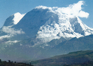
Huascarán National Park

The Mount Huascarán is the main landmark of this Peruvian National Park, home of the Andean condor and the spectacled bear

Mount Huascarán
This postcard was sent by Emerich

Huascarán is a mountain in the Peruvian province of Yungay (Ancash Region), situated in the Cordillera Blanca range of the western Andes. The highest southern summit of Huascarán (Huascarán Sur) is the highest point in Peru, the northern part of Andes (north of Lake Titicaca) and in all of the Earth's Tropics.
Huascarán gives its name to Huascarán National Park which surrounds it, and is a popular location for trekking and mountaineering. - in: wikipedia

Friday 3 February 2017

SGang Gwaay

This site has a large collection of Totem Poles, some of them real works of art

SGang Gwaay
This postcard was sent by Émilie

On the island of SG̱ang Gwaay, the remains of large cedar long houses, together with a number of carved mortuary and memorial poles at the village of SG̱ang Gwaay Llnagaay (formerly Nan Sdins), illustrate the art and way of life of the Haida. The property commemorates the living culture of the Haidaand their relationship with the land and sea. It also offers a visual key to their oral traditions. The village of SG̱ang Gwaay was occupied until shortly after 1880. What survives is unique in the world, a 19th-century Haida village where the ruins of houses and memorial or mortuary poles illustrate the power and artistry of Haida society. - in: http://whc.unesco.org/en/list/157

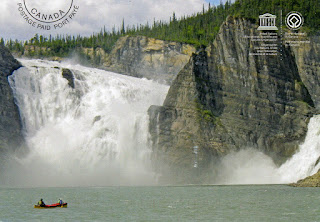
Nahanni National Park

The Nahanni River is one of the most spectacular wild rivers in North America, with deep canyons, huge waterfalls, and spectacular karst terrain, cave systems and hot springs. 

Nahanni National Park
This postcard was sent by Jason

Nahanni National Park is a 4,700 sq. km. undisturbed natural area of deep river canyons cutting through mountain ranges, with huge waterfalls and complex cave systems. The geomorphology of the park is outstanding in its wealth of form and complexity of evolution. Fluvial processes and features predominate. Within the park are examples of almost every distinct category of river or stream that is known along with one of North America’s huge waterfalls, Virginia Falls. The Flat and South Nahanni rivers are older than the mountains they dissect and have produced the finest examples of river canyons in the world, north of 60º. The injection of igneous rock through tectonic activity has resulted in spectacular granitic peaks. - in: http://whc.unesco.org/en/list/24

Miguasha National Park

This site has a great record of fossils of fish and plants, some of them dating from 370 million years ago

Miguasha National Park
This postcard was sent by Shinta

Located in Canada, on the east coast of Quebec, Miguasha National Park protects and presents the Escuminac Formation, a rock formation with a rich fossil heritage recognized for the large number of exceptionally well-preserved fossil specimens it contains which are representative of the Devonian period. The fish, invertebrate and plant fossils at Miguasha bear witness to life as it existed on Earth 370 million years ago. - in: http://whc.unesco.org/en/list/686

Gros Morne National Park

For those who like hiking this is a good destination. There are a lot of trails exploring coastal and interior areas of the park

Gros Morne National Park
This postcard was sent by Émilie

Gros Morne National Park, located on the Great Northern Peninsula in the Canadian province of Newfoundland and Labrador, illustrates some of the world’s best examples of the process of plate tectonics. Within a relatively small area are classic, textbook examples of monumental earth-building and modifying forces that are unique in terms of their clarity, expression and ease of access. The property presents the complete portrayal of the geological events that took place when the ancient continental margin of North America was modified by plate movement by emplacement of a large, relocated portion of oceanic crust and ocean floor sediments. The park also presents an outstanding demonstration of glaciations in an island setting. The fjords, waterfalls and geological structures of the park combine to produce a landscape of high scenic value - in: http://whc.unesco.org/en/list/419

Ancient Maya City and Protected Tropical Forests of Calakmul, Campeche

Calakmul is one of the wonderful ancient Maya cities of Mexico

Jade Masks of Calakmul
This postcard was sent by Marco

Ancient Maya City and Protected Tropical Forests of Calakmul, Campeche, Mexico is a Renomination and Extension of the existing 3,000 ha cultural World Heritage property, Ancient Maya City of Calakmul, Campeche. The property is located in the central/southern portion of the Yucatan Peninsula, in southern Mexico.
Excavations at Calakmul and Uxul, have revealed stucco friezes and mural paintings in some of the massive temple pyramids and palaces, as well as burials of kings and other members of nobility, containing a rich variety of body ornaments and other accompanying objects including elaborate jade masks, ear spools and polychrome pottery vessels. - in: http://whc.unesco.org/en/list/1061

Thursday 2 February 2017

Historic Fortified Town of Campeche

Campeche is typical harbour town from the Spanish colonial period and, according with this postcard, a city with a unique architecture and beautiful sunsets

Campeche
This postcard was sent by Irene

The Historic Fortified Town of Campeche, located in the State of Campeche, was founded in the 16th century on the coast of the Gulf of Mexico, in the Maya region of Ah-Kim-Pech by Spanish conquerors. It was the most important seaport at the time and played a major role for the conquest and evangelization of the Yucatan Peninsula, Guatemala and Chiapas. Its commercial and military importance made it the second biggest town in the Gulf of Mexico, after Mérida. Due its port importance in the sea route: Spain, Havana, Campeche, and Veracruz; as point of embarkation of the natural riches of the peninsula and political differences of the kingdoms of the old continent, ring the second half of the 16th century, Campeche, like other Caribbean towns, was systematically attacked by pirates and corsairs in the pay of enemies of Spain; this is why a large-scale defensive system was installed. This military defensive system for mid-17th century was inadequate and poorly strategic so a new fortification, hexagonal wall, integrating eight bastions, four doors and walls, was authorized, with construction started in 1686 and concluding in 1704. Subsequently, to complete the system of fortifications, the redoubt of San Jose on the east Hill of the village and the redoubt of San Miguel on the west Hill, as well as the batteries of San Lucas, San Matias and San Luis, is mainly in the area of historic monuments, at both ends and facing the sea were constructed. - in: http://whc.unesco.org/en/list/895/